Poor weekend better Wednesday and Thursday
Eastern Tasmania Forecast by Craig Brokensha (issued Friday 7th November)
Best Days: Wednesday morning, Thursday morning, Friday morning
Recap
Yesterday morning was fun with a small easing E/NE swell from 2-3ft under offshore winds, while today the swell was all but gone with 1-1.5ft leftovers across the coast.
This weekend onwards (Nov 8 onwards)
Tomorrow will start tiny but a strengthening N'ly breeze down the coast should kick up some N/NE windswell to 2ft+ later in the day at north-east facing beaches. Conditions will be poor in any case as winds persist from the N'th into the evening.
The swell should drop away from a weak 1-2ft Sunday morning as a S/SE change pushes through, so southern corners will be the only option if you're desperate.
Into next week the strong low pushing up and past us is still on track and we'll see a bonus S/SE groundswell on the backside of the system as well.
 Through Monday evening and Tuesday a fetch of broad S/SW gales will be aimed through our southern swell window, generating a solid pulse of S'ly windswell later Tuesday and then S'ly groundswell Wednesday.
Size wise, south facing beaches should reach 3ft+ later Tuesday and then peak Wednesday to 3-5ft.
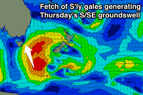
A polar fetch of S'ly gales at the base of the system through Tuesday should generate an additional S/SE groundswell for Thursday and this should come in at a similar 3-5ft across south facing beaches before easing into the afternoon and further Friday from 3ft.
Winds are the main issue and later Tuesday they're expected to be onshore from the SE, while Wednesday morning should be cleaner with a morning SW'ly before E/NE sea breezes kick in. Thursday will be good across south swell magnets with a moderate NW tending fresh N/NE breeze.
Longer term we may see some new but smaller S'ly swell into next weekend from another cold outbreak, but we'll review this Monday. Have a great weekend!

