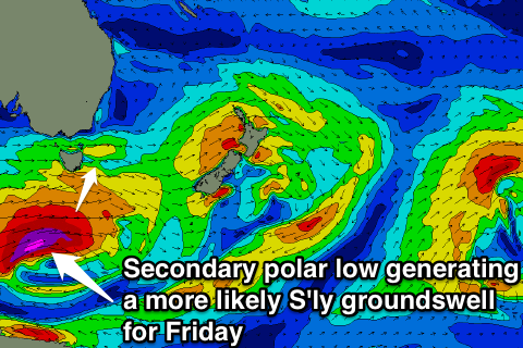
Tiny to flat, with a flukey S'ly swell for Friday at swell magnets
Eastern Tasmania Forecast by Craig Brokensha (issued Monday 27th October)
Best Days: Friday at south swell magnets
Recap
A small fun NE windswell with a S'ly wind provided good waves in southern corners on Saturday while Sunday was tiny with a leftover 1-1.5ft of swell.
A better increase in NE swell today hasn't lined up as nicely with the fetch of strong to gale-force NE winds being a touch weaker than was forecast on Friday.
Instead a sloppy 2-3ft of swell was pushing down the coast this morning, but a W'ly change this afternoon would of created fun peaks across most beaches for those in the area.

This week (Oct 28 - 31)
There isn't expected to be any NE swell left across the coast tomorrow and a strong to gale-force W'ly change associated with a vigorous low pushing across us looks to generate winds too west in nature to generate any meaningful swell for us at all!
As the system pushes past our south-east corner, a fetch of SW gales Tuesday night may produce a tiny S'ly swell Wednesday but only to 1-2ft max across south facing breaks.
A better aligned polar frontal system is due to fire up during Wednesday, aiming a fetch of severe-gale W/SW winds through our swell window. With the system being positioned further south, the swell will be able to spread out more radially up and into us, producing a good inconsistent S'ly groundswell for Friday.
South swell magnets should pick up inconsistent 2ft to possibly 3ft sets most of the day under favourable W/NW tending strong N'ly winds. Come Saturday there'll be no swell left over with tiny waves due across the coast.
This weekend onwards (Nov 1 onwards)
As touched on above, Saturday is expected to be tiny, with the next increase in size likely Monday as a change pushes up the coast kicking up a weak windswell. We'll review this Wednesday though.

