Small clean waves at exposed spots
Eastern Tasmania Forecast by Craig Brokensha (issued Monday 1st September)
Best Days: Every day for a grovel until Sunday
Recap
Good levels of E'ly groundswell held into yesterday to 3-4ft across open beaches, but a pronounced drop in size should have been seen into the afternoon, and further down from 2ft+ this morning, mixed in with a south swell.
This week and weekend (Sep 4 - 7)
The E'ly swell will continue to fade into tomorrow but new levels of E/NE swell are due to halt the easing trend further from 1-2ft into Friday and Saturday. This swell will be generated by a fetch of strong E/NE winds wrapping around the south-eastern flank of a the powerful Tasman Low currently off the East Coast.
The low will then generate a fetch of strong SE winds through our swell window Friday, generating another small E/SE swell for Sunday to a small 1ft to maybe 2ft.
From here on though that will be the end of the east swell and we'll begin to see some new NE windswell (discussed below).
Winds should be favourable each morning over the coming days and offshore, with Sunday seeing a strengthening N'ly into the afternoon.
Next week onwards (Sep 8 onwards)
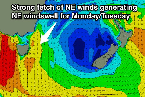
 The combination of a strong high moving into the Tasman Sea along with a vigorous cold front pushing across the southern states should producing a strengthen fetch of NE winds aimed into us Monday and Tuesday.
This should kick up moderate levels of NE windswell, reaching 3ft+ later Monday and then easing from a similar size Tuesday as winds swing offshore from the N/NW tending NW.
Longer term there's nothing major on the cards as the westerly storm track kicks into gear, associated with a strong node of the Long Wave Trough pushing in from the west. More on this Friday though.

