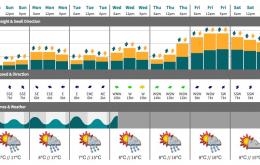
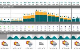
Nothing great expected to round off the working week.
Primary tabs
/reports/forecaster-notes/sydney-hunter-illawarra/2015/06/24/small-and-average-short-term-next-week
thermalben
Wednesday, 24 June 2015
/reports/forecaster-notes/sydney-hunter-illawarra/2015/06/22/easing-southerly-swell-all-week
thermalben
Monday, 22 June 2015
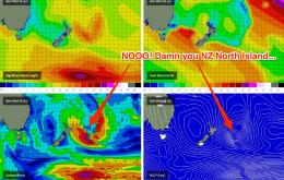
Unfortunately, we’re on the backside of the current event so it’s only going to get smaller form here on.
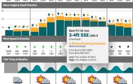
/reports/forecaster-notes/sydney-hunter-illawarra/2015/06/19/lots-sse-and-sly-swell-ahead-ely-swell
thermalben
Friday, 19 June 2015
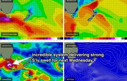
We’ve got a strong but easing S/SE swell expected all day Saturday, ahead of a new S’ly groundswell arriving late Saturday afternoon that’ll dominate proceedings on Sunday.
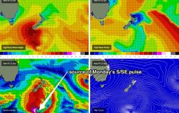
/reports/forecaster-notes/sydney-hunter-illawarra/2015/06/17/plenty-sly-swell-windy-times-sunday-pick
thermalben
Wednesday, 17 June 2015
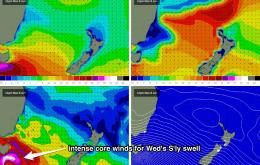
A broad trough developing across the southern Tasman Sea is expected to form two centres of low pressure over the next 24 hours.
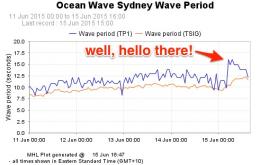
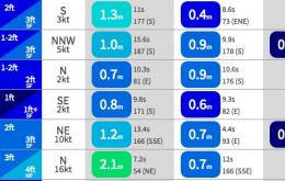
/reports/forecaster-notes/sydney-hunter-illawarra/2015/06/15/easing-sse-swell-small-ne-swell-then-run
thermalben
Monday, 15 June 2015
With today’s S/SE swell arriving a little earlier than expected, it’s fair to assume that we’ll probably see the backside of this event a little earlier than Friday’s forecast anticipated.
/reports/forecaster-notes/sydney-hunter-illawarra/2015/06/12/sly-swell-weekend-new-sse-swell-late
thermalben
Friday, 12 June 2015
Another strong front in the current progression has generated a new pulse that’ll push across the region Saturday morning.
/reports/forecaster-notes/sydney-hunter-illawarra/2015/06/10/south-swell-aplenty-southern-nsw
thermalben
Wednesday, 10 June 2015
The frontal progression responsible for the current south swell tracked a little off axis compared to Monday’s model guidance, which has resulted in a slight downgrade for Thursday.
/reports/forecaster-notes/sydney-hunter-illawarra/2015/06/08/strong-south-swell-building-wednesday
thermalben
Monday, 8 June 2015
The biggest swell from this pattern is due on Thursday, originating from the strong secondary front.
/reports/forecaster-notes/sydney-hunter-illawarra/2015/06/05/easing-sse-swell-all-weekend-strong-sly
thermalben
Friday, 5 June 2015
No major surf for the weekend but there should be good waves at south facing beaches both days.
/reports/forecaster-notes/sydney-hunter-illawarra/2015/06/03/plenty-more-sse-swell-way
thermalben
Wednesday, 3 June 2015
The Tasman Low responsible for our current swell event will deliver one final push of excellent surf, and it’s due to arrive over the coming hours.