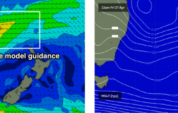
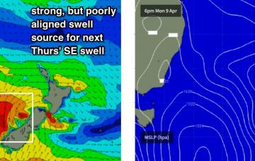
Since last Monday I’ve been discussing the possibility of an ‘unstable troughy pattern across the eastern Tasman Sea next week’, which could lead to a ‘sizeable’, ‘short range E’ly through NE swell’.
Primary tabs
/reports/forecaster-notes/sydney-hunter-illawarra/2018/04/20/fun-southerly-pulse-sunday-building-ne
thermalben
Friday, 20 April 2018
/reports/forecaster-notes/sydney-hunter-illawarra/2018/04/18/stacks-south-swell-foreseeable-future
thermalben
Wednesday, 18 April 2018
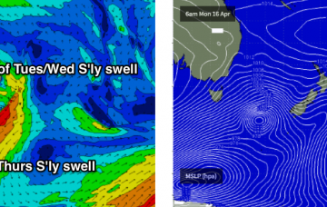
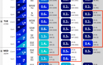
Our current S’ly swell will continue to ease into Thursday, but a new long period S’ly swell will push up through the morning, generated by a polar low south of Tasmania earlier this week.
/reports/forecaster-notes/sydney-hunter-illawarra/2018/04/16/large-series-south-swells-southern-nsw
thermalben
Monday, 16 April 2018
Model guidance has increased projected wave heights for Tuesday and Wednesday, more inline with what my Friday notes suggested.
/reports/forecaster-notes/sydney-hunter-illawarra/2018/04/13/very-small-weekend-ahead-strong-sly
thermalben
Friday, 13 April 2018
Next week is very tricky.
/reports/forecaster-notes/sydney-hunter-illawarra/2018/04/11/great-waves-friday-easing-swells-weekend
thermalben
Wednesday, 11 April 2018
Friday looks much better on the surface though with winds swinging to the NW as a weak trough moves over the area. This should clean up the beachies nicely and provide some excellent waves to finish the working week.
/reports/forecaster-notes/sydney-hunter-illawarra/2018/04/09/complex-week-se-swells-ahead-though
thermalben
Monday, 9 April 2018
For my money, Friday is the pick of the working week.

/reports/forecaster-notes/sydney-hunter-illawarra/2018/04/06/fun-weekend-ahead-interesting-swells
thermalben
Friday, 6 April 2018
Lots of interesting swell sources next week, though we’re still looking at a stubborn ridge of high pressure in the Tasman Sea, ensuring our near swell window remains relatively quiet.
/reports/forecaster-notes/sydney-hunter-illawarra/2018/04/04/fun-weekend-waves-ahead
thermalben
Wednesday, 4 April 2018
The weekend’s wind outlook has been reversed since Monday’s notes.
/reports/forecaster-notes/sydney-hunter-illawarra/2018/04/02/thursday-onwards-looking-fun-out-ene
thermalben
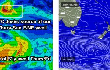
Monday, 2 April 2018
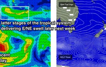
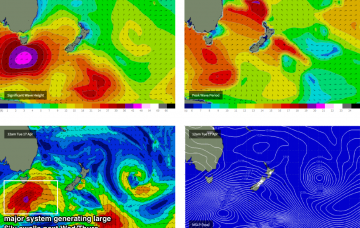
Our best new swell source for the coming week is Tropical Cyclone Josie, which formed south-west of Fiji over the weekend.
/reports/forecaster-notes/sydney-hunter-illawarra/2018/03/30/mainly-small-swells-forecast-period
thermalben
Friday, 30 March 2018
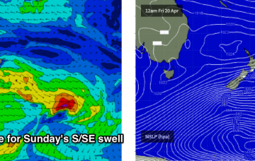
A series of powerful though poorly aligned Southern Ocean fronts and lows below Tasmania next week will generate small levels of southerly groundswell for Southern NSW.