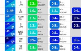
We’ve got some reall nice surf likely over the coming days.
Primary tabs
/reports/forecaster-notes/sydney-hunter-illawarra/2015/01/21/great-surf-right-across-board
thermalben
Wednesday, 21 January 2015
/reports/forecaster-notes/sydney-hunter-illawarra/2015/01/19/plenty-swell-dodgy-winds-galore
thermalben
Monday, 19 January 2015
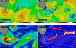
If you were to pass a casual glance across the surfcams, you’d never know that there’s actually a decent south swell in the water right now.
/reports/forecaster-notes/sydney-hunter-illawarra/2015/01/16/fun-surf-early-saturday-dicey-winds
thermalben
Friday, 16 January 2015
Today’s south swell will start to ease this evening and we can expect a steady downwards trend overnight and throughout Saturday.
/reports/forecaster-notes/sydney-hunter-illawarra/2015/01/14/return-swells-south
thermalben
Wednesday, 14 January 2015
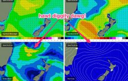
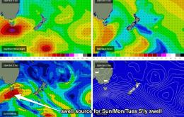
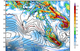
Meanwhile, we’ve got two pulses of return south swell, that will originate from the opposite side of the trough as it clears to the east.

/reports/forecaster-notes/sydney-hunter-illawarra/2015/01/12/almost-one-everything-offing
thermalben
Monday, 12 January 2015
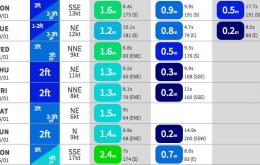
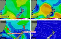
The complexities outlined in last Friday’s forecast have held nicely through into this week.
/reports/forecaster-notes/sydney-hunter-illawarra/2015/01/09/throwin-everything-wall
thermalben
Friday, 9 January 2015
We’re looking at a similar mix of short range NE windswell and some small distant E/NE swell for much of the weekend, probably similar on Saturday as per what we saw today.
/reports/forecaster-notes/sydney-hunter-illawarra/2015/01/07/plenty-swell-plenty-wind
thermalben
Wednesday, 7 January 2015
Based on today’s (under) performance I’m going to pull back Thursday’s expected size from the distant trade swell source.
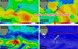
/reports/forecaster-notes/sydney-hunter-illawarra/2015/01/05/persistent-trade-swells-dynamic
thermalben
Monday, 5 January 2015
The stationary trade belt across our E/NE swell window is a beauty, and it’s going to be a source of quality surf for quite some time.
/reports/forecaster-notes/sydney-hunter-illawarra/2015/01/02/fun-waves-ahead-long-range-potentially
thermalben
Friday, 2 January 2015
A fun mix of S’ly groundswell and NE windswell is expected all weekend.
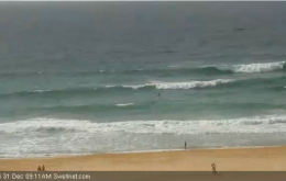
/reports/forecaster-notes/sydney-hunter-illawarra/2014/12/31/intermittent-energy-south
thermalben
Wednesday, 31 December 2014
We’ve got some more south swell due over the coming days, generated by the parent low to the front that whipped up today’s pulse.