Fun waves ahead; long range potentially solid
Sydney, Hunter and Illawarra Surf Forecast by Ben Matson (issued Friday 2nd January)
Best Days: Sat/Sun: fun mix of E/NE, NE and S'ly swells (aim for northern corner as NE winds will probably ruin open beaches). Wed onwards: fun trade swell building into the weekend, may posisbly get solid later in the weekend or early the following week.
Recap: Fun mix of swell both days, consisting of S’ly and E/NE swell in the 2ft+ range. Light winds early, freshening NE Thursday afternoon and S’ly today.
This weekend (Jan 3-4)
*forecast notes will be brief this week*
A fun mix of S’ly groundswell and NE windswell is expected all weekend, although winds will strengthen from the NE rendering most beaches quite bumpy at times.
On Wednesday, model data had “pulled back the strength and scope of the local NE winds in our immediate swell window”, so wave heights were eased a touch. In the latest guidance they’ve gone back to the initial progs from Monday, so I’ve bumped it back up again - we should see 2-3ft sets at times from this source (probably later Saturday and most of Sunday).
The southerly groundswell will be very inconsistent, and is also expected to pulse most strongly from late Saturday and into Sunday. Expect long breaks between 2-3ft sets at south swell magnets, perhaps a little bigger in the Hunter. But the local NE swell will probably be the most useful energy.
Winds are expected to ease a little into Sunday afternoon as a trough moves along the southern NSW coast - this could even result in a reasonable period of light variable winds on the South Coast (although this is less likely north of Wollongong) before winds swing fresh southerly. This change is due into Sydney in the evening.
Next week (Jan 5 onwards)
The models have finally wiped out any chances of the weekend’s troughy pattern evolving into a low in the Tasman Sea early next week. But the good news is that we’ve got plenty of swell in store for the longer term period.
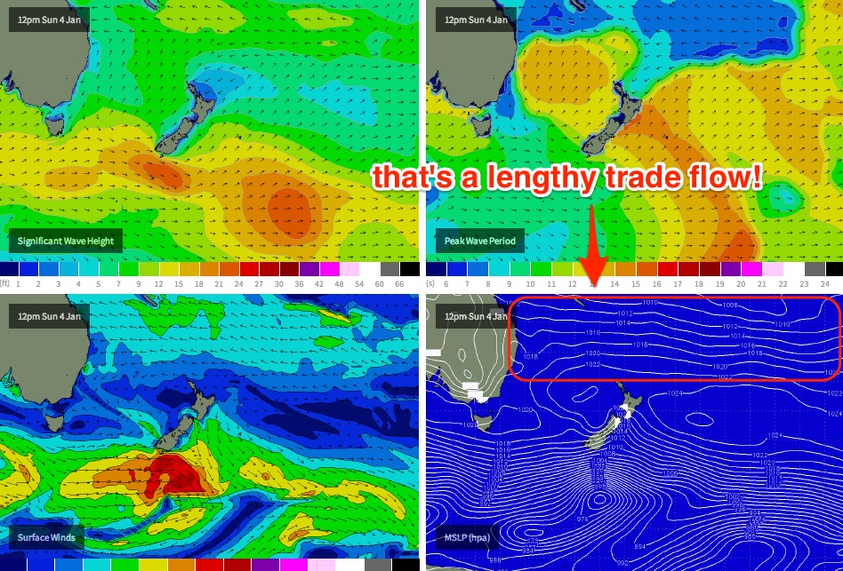
A series of Southern Ocean fronts will provide small southerly swell across Southern NSW next week, however of much greater interest is a broad strengthening trade flow about the northern Tasman Sea. This pattern is expected to remain anchored in place from the western Coral Sea through to the South West Pacific Ocean for most of next week and beyond.
Although the winds within this fetch are not expected to become overly strong - yet - its sheer length and breadth (see chart below) will result in an very good, sustained trade swell for the entire East Coast. Wave heights will be biggest in the SE Qld/Northern NSW region but we should see a healthy spread of surf across Southern NSW too.
At this stage Monday is expected to see a small mix of peaky, easing swells from the weekend’s sources, with wave heights bottoming out into Tuesday morning. The aforementioned trade swell will then start to push through very late on Tuesday, with a steady upwards trend expected Wednesday (2-3ft open beaches) and we may see a little more size through the back half of the week.
As for local winds, we’re looking at a steady NE pattern for much of next week, with periods of light winds at times - mainly in the mornings. A southerly change (and associated increase in S’ly groundswell) is also on the cards for next Friday/Saturday.
But back to the trade pattern: there’s also a suggestion that we could see a tropical depression in the Fijian region intensify within the back half of this fetch later next week, which could result in a strong E/NE groundswell later next weekend or early in the following week (sometime around Jan 11/12). I’ll have more details on this on Monday.


Comments
No fun waves at all this week. Not a one!