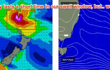
Long term prospects remain dynamic.
Primary tabs
/reports/forecaster-notes/sydney-hunter-illawarra/2018/03/23/tricky-weekend-waves-next-week-looks
thermalben
Friday, 23 March 2018
/reports/forecaster-notes/sydney-hunter-illawarra/2018/03/21/large-windy-surf-finish-week-average
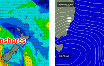
thermalben
Wednesday, 21 March 2018
In short: flag the next few days. Too much effort is required for (likely) too little gain.
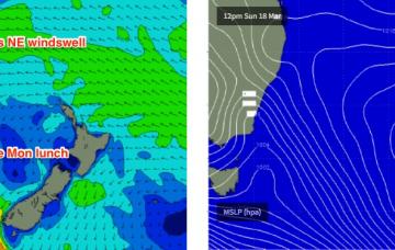
/reports/forecaster-notes/sydney-hunter-illawarra/2018/03/19/lots-onshore-wind-week-sunday-pick
thermalben
Monday, 19 March 2018
Most of this week looks horribly onshore.
/reports/forecaster-notes/sydney-hunter-illawarra/2018/03/16/make-most-saturday-much-next-week-looks
thermalben
Friday, 16 March 2018
The new long period swell modeled to arrive later today should push through overnight and provide a full day of inconsistent, flukey south swell into Saturday.
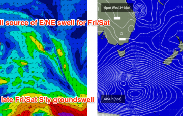
/reports/forecaster-notes/sydney-hunter-illawarra/2018/03/14/plenty-waves-ahead-southern-nsw
thermalben
Wednesday, 14 March 2018
We have a couple of flukey new swell sources expected over the coming days.
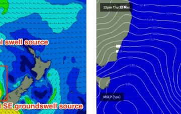
/reports/forecaster-notes/sydney-hunter-illawarra/2018/03/12/stacks-great-surf-ahead-just-about-every
thermalben
Monday, 12 March 2018
We’ve got waves from just about everywhere this week.
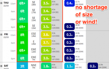
/reports/forecaster-notes/sydney-hunter-illawarra/2018/03/09/fun-weekend-waves-dynamic-week-ahead
thermalben
Friday, 9 March 2018
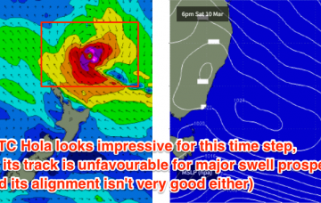
Wow, what a dynamic week in store for Southern NSW. In fact the whole East Coast looks really exciting from a forecasting point of view right now.
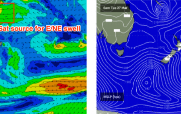
/reports/forecaster-notes/sydney-hunter-illawarra/2018/03/07/broad-mix-swells-throughout-period-good
thermalben
Wednesday, 7 March 2018
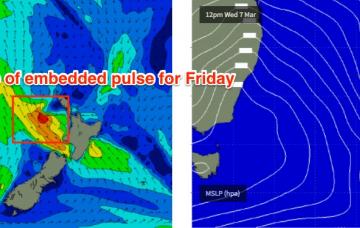
There’s a more curious swell source on the cards, that was missed in Monday’s notes and is showing up in the model guidance for the end of the week.
/reports/forecaster-notes/sydney-hunter-illawarra/2018/03/05/plenty-se-swell-all-week-tricky-winds
thermalben
Monday, 5 March 2018
The ridge will then hold firm across the Northern Tasman Sea through the rest of the week and even into the weekend.
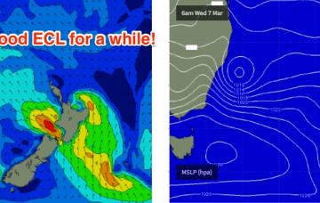
/reports/forecaster-notes/sydney-hunter-illawarra/2018/03/02/ecl-inbound-next-week
thermalben
Friday, 2 March 2018
The weekend’s southerly change will be associated with a surface trough, which is expected to stall just below the Mid North Coast on Sunday, freshening southerly winds through our short range swell window as a Tasman Low develops in the central/southern Tasman Sea.