Large windy surf to finish the week, average weekend ahead
Sydney, Hunter and Illawarra Surf Forecast by Ben Matson (issued Wednesday 21st March)
Best Days: Protected corners only for the next few days. Mon: peaky NE swell with early light offshore winds.
Recap: Small leftovers and freshening S’ly winds Tuesday morning, building steadily through the afternoon and more strongly into today, though very bumpy with fresh to strong onshore winds. Some exposed beaches are now pushing north of 6ft though quality is pretty low. Wave heights are larger across the Hunter as the fetch is a little stronger and more focused into that region.
Today’s Forecaster Notes are brought to you by Rip Curl
This week (Mar 20th - 23rd)
No change for the rest of the week.
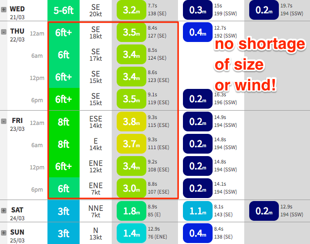
Gusty onshore winds will persist through Thursday though slowly ease in speed, before a more pronounced abating trend occurs into Friday. The direction will gradually swing anti-clockwise, from the SE to the E/SE, E then E/NE, and by Friday could be only light to moderate in strength - but with four days of easterlies under the belt, it’s going to take some time for conditions to start to improve.
As for surf size, I must admit I was a little skeptical on Monday’s model guidance of 8-10ft through this period, though today’s size (6ft sets) is a lot better than we’d ordinarily see from what’s a relatively modest-strength fetch in the Central Tasman Sea. Wave heights are somewhat exaggerated due to the stationary nature of the fetch and its impressive length, so taking this into account with the 48 hour synoptic, and it’s certainly quite plausible that exposed beaches between Sydney and the Hunter could reach the model-estimated size range.
Of course, these locations won’t be surfable at all and as the wind swings more direct onshore, we’ll see decreasing protected opportunities too. As such you’ll have to look towards novelty breaks, though I just can’t see there being any quality worth getting excited about.
So in short: flag the next few days. Too much effort is required for (likely) too little gain.

This weekend (Mar 24th - 25th)
The weekend outlook has deteriorated since Monday’s notes. Not due to swell prospects - there’ll be no shortage of energy - but surf quality.
Saturday was always dubious with northerlies likely to play a strong influence, but we’re now looking at continuing N’ly tending NE winds into Sunday, instead of a period of early NW winds.
We’ll see swell from a few sources though. Friday’s local fetch will ease rapidly into the weekend, and therefore so too will wave heights into Saturday.
However, a secondary low developing off the southern end of New Zealand’s South Island today will generate a second round of SE swell that’s due to fill in later Friday, and persist into Saturday with 3-5ft sets.
Both swell sources will then ease steadily into Sunday but Saturday’s freshening N’ly tending NE flow should whip up some peaky NE windswell, holding through Sunday in the 2-3ft+ range at NE facing beaches. Unfortunately, the only workable options will be sheltered northern corners (which won’t pick up the NE swell) but there’ll be enough leftover E’ly and SE swell to make it worth a quick paddle if you're extremely keen.
Next week (Mar 26th onwards)
Sunday’s strengthening NE flow is expected to maintain peaky 2-3ft waves into Monday morning, and an approaching southerly change should result in clean conditions early morning as winds swing to the west just prior to its arrival. This time frame is currently the pick of the forecast period.
A strong front and low crossing the Tasmanian divide around this time will then create a couple of small south swells for Tuesday and Wednesday - the former sourced from strong W/SW winds exiting eastern Bass Strait on Monday; the latter sourced from the parent low further south, as it concurrently crosses the waters south of Tasmania.
No great size is expected at this stage but it’ll generate some useful energy for our mid-week surf prospects, however local conditions could be a little ordinary as the associated southerly glow impacts the coast (mainly Tuesday).
Long term prospects still look dynamic with a developing E’ly flow north of NZ over the weekend generating some small E/NE swell, and a tropical low (or cyclone) near New Caledonia around Monday potentially merging with a broad trough related to the frontal passage in the Tasman Sea around the same time, which may lead to the development of a more significant swell generating system in the north-eastern Tasman Sea mid-late next week.
Let’s take a closer look on Friday.

