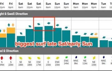
The models every so slightly eaed back the stretch of the E’ly fetch out of Cook Strait, so the resulting E/SE swell for Thursday will be a little smaller and a little later in its arrival than was suggested on Monday.
Primary tabs
/reports/forecaster-notes/sydney-hunter-illawarra/2017/04/05/quality-ese-swell-late-thursday-early
thermalben
Wednesday, 5 April 2017
/reports/forecaster-notes/sydney-hunter-illawarra/2017/04/03/thursday-and-friday-pick-forecast-period
thermalben
Monday, 3 April 2017
Plenty of surf this week but tricky winds for the next few days.
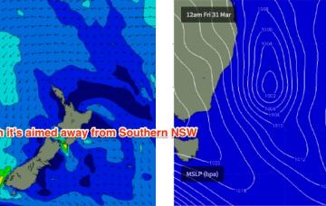
/reports/forecaster-notes/sydney-hunter-illawarra/2017/03/31/stacks-swell-southern-nsw-looking-best
thermalben
Friday, 31 March 2017
The second half of next week looks unreal.
/reports/forecaster-notes/sydney-hunter-illawarra/2017/03/29/windy-conditions-ahead-southern-nsw-few
thermalben
Wednesday, 29 March 2017
Saturday should be OK though it may be a little lumpy and leftover from Friday’s winds.
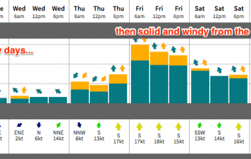
/reports/forecaster-notes/sydney-hunter-illawarra/2017/03/27/small-surf-initially-then-solid-and
thermalben
Monday, 27 March 2017
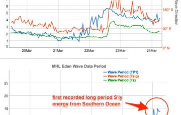
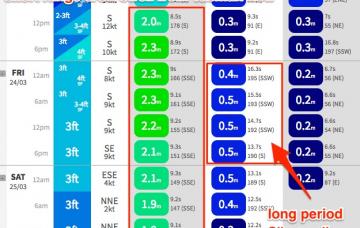
On Sunday, a very long period (19-20+ second) S’ly groundswell - originating from a sneaky polar off the Ice Shelf south of SA this Wed and Thurs - is expected to make landfall across the Sydney region.
/reports/forecaster-notes/sydney-hunter-illawarra/2017/03/24/great-weekend-across-southern-nsw-not
thermalben
Friday, 24 March 2017
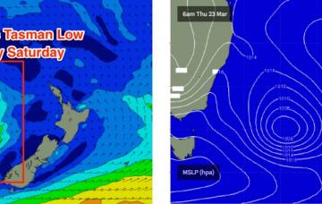
The models have ever so slightly delayed the backside phase of the Tasman Low for today, which means it’ll remain active for a little longer than anticipated in Wednesday’s notes, and will therefore provide good quality surf for more of the weekend.
/reports/forecaster-notes/sydney-hunter-illawarra/2017/03/22/friday-and-saturday-pick-forecast-period
thermalben
Wednesday, 22 March 2017
A new Tasman Low is developing at the moment, and it will generate a fresh S/SE swell that’s expected to build throughout the day
/reports/forecaster-notes/sydney-hunter-illawarra/2017/03/20/average-surf-ahead-southern-nsw-best
thermalben
Monday, 20 March 2017
A broad inland trough across the eastern states is slowly shifting eastwards. It’s freshening NE winds about the Southern NSW coast but ultimately won’t generate much quality surf over the next few days, owing to a lack of strength in the surface wind field.
/reports/forecaster-notes/sydney-hunter-illawarra/2017/03/17/large-windy-surf-ahead-sydney-region
thermalben
Friday, 17 March 2017
We’ve got a wild weekend of wind, rain and large surf ahead.
/reports/forecaster-notes/sydney-hunter-illawarra/2017/03/15/tricky-winds-plenty-surf-ahead-southern
thermalben
Wednesday, 15 March 2017
There’s no real change to the forecast for the rest of the week, however Friday’s looking pretty complex locally as a low develops off the coast.