Tricky winds but plenty of surf ahead for Southern NSW
Sydney, Hunter and Illawarra Surf Forecast by Ben Matson (issued Wednesday 15th March)
Best Days: Plenty of E/NE swell throughout the entire period though winds will be tricky at times. Thursday afternoon, Sunday afternoon and Monday look to be the pick right now.
Recap: Onshore winds have created ordinary surf conditions over the last few days though wave heights have slowly built, with 3-4ft sets now showing across most Sydney beaches.
This week (Mar 16th - 17th)
There’s no real change to the forecast for the rest of the week, however Friday’s looking pretty complex locally as a low develops off the coast.
Thursday will see the existing E/NE swell ratchet up a little more from today, though the models have eased back the strength of the Tasman infeed, so there’s a chance the increase may not be discernible. The trough along the coast will drop south throughout the day, resulting in early NE winds tending N’ly mid-late morning then light NW into the afternoon (delayed timing on this further south), so it’s looking best for a paddle after lunch as we’ll see the best conditions then.
NE facing beaches should hover somewhere between 3ft and maybe 5ft (smaller at south facing beaches), with a likely peak into the afternoon. The only concern is for the South Coast which may see a later wind transition compared to Sydney, Hunter and Illawarra coasts.
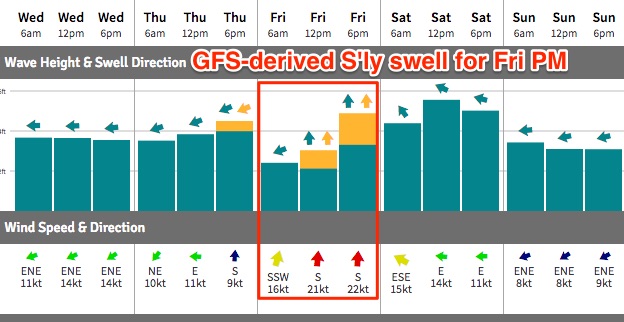
On Friday this E/NE swell will ease back in size to around 2-3ft+, but the wind outlook is very complex - the models are still not agreeing on where a small surface low will form - some have it east of the Hunter, others off the South Coast. In most cases we’re looking at freshening southerlies throughout the day, however the US solution (GFS) is more aggressive with strong to gale force winds likely to whip up a strong southerly windswell for the afternoon (4-5ft at south facing beaches).
This atmospheric model is driving our automated surf model (and thus its height predictions, see below), however it’s probably worth tempering expectations from this source.
Regardless, Friday morning is probably your best time to surf as winds will certainly pick up throughout the day and may also swing S/SE. The E/NE swell source is also expected to ease during the day too.

This weekend (Mar 18th - 19th)
Although the models are shaky on Friday’s wind specifics, they are in general agreement for Saturday - onshore right across the region.
Whatever south swell we see build throughout Friday will be on the way down (so, it’s too early to have confidence in the likely size) and there’ll also be a small undercurrent of E/NE swell in the mix (2-3ft sets).
But with these winds it’s looking like a write-off.
Sunday eases the onshore flow though without a synoptic offshore we’re unlikely to see a rapid improvement in surface conditions. Winds are likely to remain out of there east though should become light throughout the day. So the afternoon is probably a better choice for a paddle.
As for surf, a developing E’ly dip between Northern NSW and New Caledonia on Friday is expected to generate a strong increase in E’ly swell for northern regions on Sunday, however we’ll see a smaller spread from this source across Southern NSW with a peak into the afternoon. Our surf model is calling for around 3ft of surf which I think is slightly undercooking it; I wouldn’t be surprised if reliable NE swell magnets pick up a few 3-4ft sets late in the day (smaller at dawn). But by and large Sunday afternoon is looking like the best window of the weekend.
Next week (Mar 20th onwards)
There’s nothing major expected next week, however we will see a steady supply of small useful from the Northern Tasman Sea.
A strong ridge across this region over the weekend will persist through early next week which means we’re looking at fun E/NE swells easing slowly from around 3ft on Monday morning down to 2ft by Wednesday afternoon or Thursday morning.
Elsewhere, a steady stream of Southern Ocean fronts look like they’ll be too zonal (west-east) in alignment to favour our swell window.
Locally, a persistent coastal trough will maintain NE winds about the region - possibly just enough to kick up some small wind waves though no major surf is currently expected from this source.
See you Friday!

