Easing surf with less favourable winds

Western Australian forecast by Craig Brokensha (issued Wednesday April 16th)
Best Days: Protected spots tomorrow morning, South West magnets Saturday morning and Sunday, Monday
Features of the Forecast (tl;dr)
- Peak in SW swell later today, easing slowly tomorrow with mod-fresh S/SE-SE winds, strengthening and tending more S'th
- Smaller Fri, with a reinforcing mid-period SW swell in the water along with strong S/SE winds
- Easing surf Sat with moderate E-E/NE winds ahead of weak sea breezes
- Small reinforcing SW swell Sun with fresh E/NE tending variable winds
- Large, inconsistent SW groundswell building Mon, peaking later, easing Tue
- Fresh E/NE winds, tending variable Mon, with S/SE tending W/SW winds Tue
- Likely large SW groundswell for mid-late next week
Recap
The surf continued to ease into yesterday though the South West was still in the 4ft range with tiny waves to the north under morning offshores.
Today our new building SW swell is showing across the South West with building sets to the 6ft range through the morning under an offshore breeze. Perth and Mandurah were tiny with a little increase now being seen across the latter.

Great surf with the building swell this morning
This week and next (Apr 17 - 25)
The current, building SW swell is due to reach the 8ft range into this afternoon/evening across the South West with 2ft to possibly 3ft waves in Mandurah and 2ft+ sets across Perth but with sea breezes.
We can expect the swell to then slowly ease through tomorrow from 6-8ft in the South West and 2ft+ across metro locations under a moderate to fresh S/SE-SE breeze, strengthening through the morning and then shifting more S'ly.
This will limit the best waves to protected spots with Friday coming in smaller along with strong S/SE winds that might tend SE for a period across metro locations.
There should be a reinforcing pulse of mid-period SW swell in the mix Friday though, generated by a slim fetch of strong to gale-force W/WNW winds to our south-west today but no major size is due above 4-6ft in the South West, maybe 1-2ft Mandurah and 1-1.5ft Perth.
The weekend looks cleaner with an E-E/NE offshore on Saturday with easing surf across the South West from the 4ft range, tiny to the north. Weak sea breezes are due with Sunday seeing fresher E/NE winds, variable into the afternoon and a small reinforcing SW swell to a similar size.
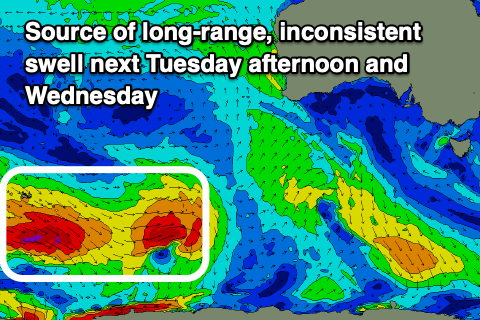
Now, moving into Monday/Tuesday, we’re expected to see an inconsistent, long-range SW groundswell filling in, with it generated by a strong polar low that formed south of South Africa earlier this week.
The low has already generated a fetch of severe-gale W’ly winds in our far swell window, with a secondary frontal system now pushing up on the tail of the initial system, generating an additional fetch of gale to severe-gale W/NW winds.
This should produce a large, inconsistent SW groundswell that will build Monday with a peak likely into the evening if not overnight, easing slowly Tuesday morning.
The South West should see inconsistent sets to 8ft+ across the magnets with 2ft to possibly 3ft waves in Mandurah, 2ft+ Perth before easing from 8ft, 2ft to possibly 3ft and 2ft+ respectively Tuesday morning.
Fresh E/NE tending variable winds are due Monday as the swell builds with a trough due to bring S/SE tending W/SW winds Tuesday. With this, Monday looks to be the pick of the coming swell.
Following the swell early week, we’re looking at another, large back up through the middle to end of the week, produced by a strong polar low projecting towards us on the weekend and into Monday. More on this Friday though.