Fun weekend with less favourable winds

Western Australian forecast by Craig Brokensha (issued Friday April 11th)
Best Days: Today, protected spots tomorrow, Sunday from mid-late morning, Tuesday morning Perth and Mandurah, Thursday morning Perth and Mandurah
Features of the Forecast (tl;dr)
- Easing SW swell tomorrow, with a large, inconsistent reinforcing SW groundswell for Sun AM, easing
- Strengthening S/SE winds tomorrow, strong SE tending E/SE Sun, back to the SE later
- Strong W/SW-SW winds Mon, variable offshor early around Margs
- Easing S/SW windswell Tue with morning S/SW winds, more E/SE-SE in Perth and Mandurah
- Large mid-period SW swell building later Wed, peaking Thu
- Light E winds ahead of sea breezes Wed, strong S Thu
- S/SE winds Fri
Recap
Yesterday started fun and clean with 4-5ft waves across the South West and small 1-2ft sets in Mandurah, 1-1.5ft Perth, with the new pulse of mid-period swell only arriving once sea breezes kicked in across all locations.
Today is the pick though with a peak in swell to 8ft in the South West, 3ft across Mandurah and 2ft+ in Perth with a great, offshore wind. Sea breezes will develop into the afternoon but without any major strength though this morning was the pick of it.

Clean, incoming sets this morning
This weekend and next week (Apr 12 - 18)
Today’s large mid-period swell is due to ease back into tomorrow, though we’re due to see the long-range groundswell, generated by the earlier stages of the frontal progression linked to the current swell filling in Sunday.

It’ll be inconsistent but sets to 8ft are again due across the South West with 2-3ft waves in Mandurah, 2ft+ across Perth with much longer waits between sets.
Local winds tomorrow won’t be as favourable with a trough moving in overnight due to bring strengthening S/SE winds, much better Sunday under strong SE tending E/SE winds, switching back SE again into the afternoon.
Now, moving into early next week, we’re set to see a mid-latitude low pushing across us Monday, with early offshore winds and smaller surf due to become choppy as SW winds arrive through the mid-morning. Perth and Mandurah will be onshore from the get go.
Winds will linger from the S/SW into Tuesday in the wake of the low across the South West with no major swell, while Perth and Mandurah are likely to offer windswelly 1-2ft waves under a morning offshore.
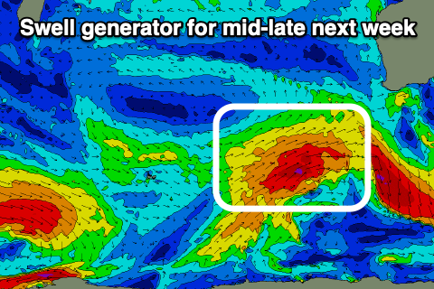
Of greater significance is a healthy polar frontal system projecting towards us Sunday and Monday from just east of the Heard Island region. A great fetch of gale to severe-gale SW winds should produce a large increase in SW swell later Wednesday before peaking Thursday, with the South West due to come in around the 8ft range, 2-3ft Mandurah and 2ft+ Perth.
Local winds as the swell builds Wednesday look offshore ahead of sea breezes, with a trough moving in Thursday, followed by high pressure resulting in unfavourable, strong S’ly winds.
The S’ly winds look to ease and tend more S/SE into Thursday as the swell eases, offshore Friday but much smaller.
Following this we’re only looking at moderate swell pulses, but more on this Monday. Have a great weekend!