Great end to the week, options for the weekend

Western Australian forecast by Craig Brokensha (issued Wednesday April 9th)
Best Days: The South West tomorrow morning, Friday, Saturday morning Perth and Mandurah, Sunday, Monday morning in the South West
Features of the Forecast (tl;dr)
- Large, mid-period SW swell building later tomorrow, peaking Fri
- Moderate E/SE tending strong S/SW winds tomorrow, light E-E/NE Fri ahead of a mid-late afternoon S-S/SW change
- Slight drop in swell Sat AM, with a large, long-range (inconsistent) SW groundswell building later in the day, peaking Sun
- Strong S-S/SW winds Sat (S/SE early to the north)
- Fresh to strong E/SE winds Sun, possibly tending SE into the PM
- Easing swell Mon with fresh SE tending strong S-S/SW winds
- Smaller Tue with variable tending strong S-S/SW winds
- Possible building W/SW swell mid-next week with S/SE winds
Recap
The surf has been on the tiny side of the coin across the metro locations yesterday and this morning while Monday’s swell across the South West still came in at 4-5ft yesterday morning with workable, cross-shore S/SE winds. Today was smaller and lumpier with a weak southerly breeze.
This week and next (Apr 10 - 18)
After a slow couple of days we’ve got some better groundswell on the cards from tomorrow afternoon but more so through Friday.
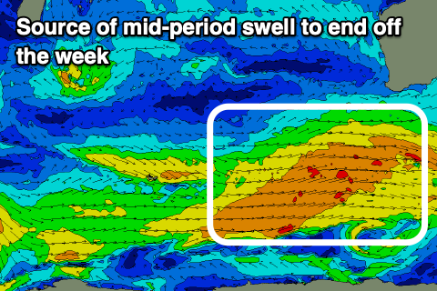
Tomorrow afternoon and Friday’s swells will be mid-period in nature, generated by a great fetch of strong to sub-gale-force W/SW winds currently south-west of us. This progression is actually the same storm linked to some longer period swell arriving Sunday, generated by a distant but more significant fetch of gale to severe-gale W’ly winds to the south and south-east of South Africa earlier this week.
Size wise, both swells look similar with a building trend due tomorrow afternoon, reaching 6ft+ or so later in the South West, with 8ft sets across exposed breaks Friday, 2-3ft waves in Mandurah and 2ft+ surf across Perth.
Winds tomorrow look light offshore across all locations ahead of strong sea breezes when the swell starts to arrive, light E-E/NE on Friday morning when it peaks. A trough looks to bring strong S-S/SW winds mid-late afternoon Friday so surf before then.

Now, a temporary easing trend is due through Saturday ahead of the arrival of the long-range SW groundswell through Sunday. It might be seen later in the day Saturday but Sunday should reveal inconsistent but good sets back to 8ft in the South West (6-8ft generally), 2ft to occasionally 3ft Mandurah and 2ft+ Perth.
Unfortunately in the wake of the trough Friday, strong S-S/SW winds look to linger across the South West Saturday with a S/SE offshore to the north in Perth and Mandurah through the morning.
Sunday should come in much cleaner with a fresh to strong E/SE offshore that may hold most of the day if only tending SE into the mid-late afternoon.
Into next week it looks like winds from the south-eastern quadrant will dominate proceedings with easing surf through Monday and Tuesday.
The Southern Ocean swell sources will dry up and we’re only expecting small to moderate sized, mid-period pulses through the middle to end of the week.
The first for Wednesday will be generated by a polar low that’s currently south of South Africa, generating a fetch of strong W/NW winds that will weaken into tomorrow.
EC has a better swell generating system projecting towards us early next week, north in latitude through the Indian Ocean and this could generate a bit more close-range swell energy on top of the small distant swell, but we’ll have to have a closer look at this Friday.