Less reliable week of surf, best later

Western Australian forecast by Craig Brokensha (issued Monday April 7th)
Best Days: Friday ahead of sea breezes
Features of the Forecast (tl;dr)
- Easing S/SW swell tomorrow with S/SE tending S/SW winds (SE to the north)
- Small mid-period W/SW swell building Wed with similar winds to Wed
- Largem mid-period SW swell building later Thu, peaking Fri with gusty S/SE tending strong S/SW winds Thu, fresh E ahead of relatively weak sea breezes Fri
- Slight drop in swell Sat AM, with a large, long-range SW groundswell building later Sat, peaking Sun
- Possibly early variable tending W/SW-SW winds Sat, gusty S-S/SW on Sun
- Easing surf next week S/SE tending S/SW winds
Recap
The South West offered the best waves over the weekend with a fun pulse of new S/SW swell into Friday afternoon/evening, holding a good 4-5ft into Saturday morning with favourable conditions most of the day.
Yesterday was smaller but still fun across the small wave breaks, while into the late afternoon, another pulse of S/SW groundswell filled in and this has peaked today to a good 4-6ft across the South West magnets with 1-1.5ft sets to the north.
This week and weekend (Apr 8 - 13)
Looking at the week ahead, and the coming days aren’t as favourable as we have seen with the current swell due to ease as the heat trough that was sitting west of us breaks down and drifts east, bringing with it unfavourable winds.
Tomorrow will see S/SE tending S/SW winds in the South West with today’s swell on the decline, smaller Wednesday morning with similar winds. Perth and Mandurah should be cleaner but with tiny surf.
Into Wednesday afternoon, a small mid-period W/SW swell is due, generated by a mid-latitude low that formed south-east of Madagascar on the weekend. It only looks to produce a tiny 1-1.5ft wave across Perth and Mandurah with slow 4-5ft sets across the South West.
Now, from Thursday afternoon onwards, we should see building levels of more significant swell across the region, though the size has been downgraded since last week.
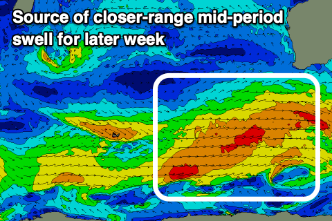
An initial strong polar low forming south of South Africa has done so, with various fetches of severe-gale W-W/NW winds due to produce a large, long-range though inconsistent SW groundswell for later Saturday but more so Sunday.
Now, this low will push east fast while weakening over the coming days, restrengthening again south-west of us through Wednesday/Thursday.
The wind strengths look below gale-force though and with this, the size and energy for this mid-period swell for later Thursday and Friday looks to now come in at around the 8ft+ range across the South West, 2ft to occasionally 3ft Mandurah and 2ft+ Perth along with S/SE tending strong S/SW winds Thursday, much better and fresh E’ly Friday ahead of later sea breezes.

Into the weekend as the less consistent, long-range energy arrives, we’re due to see winds deteriorate thanks to a possible mid-latitude low forming west of us. Early Saturday may see variable winds with S’ly breezes into Sunday.
Size wise the long-range swell looks similar to Friday’s but with way less consistency.
Cleaner conditions are due next week as the swell eases with nothing too major on the cards at this stage until the following weekend.