Small weekend, stronger mid-late next week
Western Australian forecast by Craig Brokensha (issued Friday March 28th)
Best Days: Sunday morning in the South West, Thursday morning in the South West, Friday and Saturday next week
Features of the Forecast (tl;dr)
- Easing swell tomorrow with fresh E/SE-SE winds ahead of sea breezes tomorrow
- Small mid-period S/SW swell Sun with mod-fresh E/SE winds ahead of sea breezes
- E winds Mon with small levels of swell
- Small-mod sized, S/SW groundswell Tue with strengthening S-S/SE winds
- Moderate sized, mid-period S/SW swell building Wed PM with SE tending strong S/SE winds, easing Wed with gusty E/SE-SE tending S/SE winds
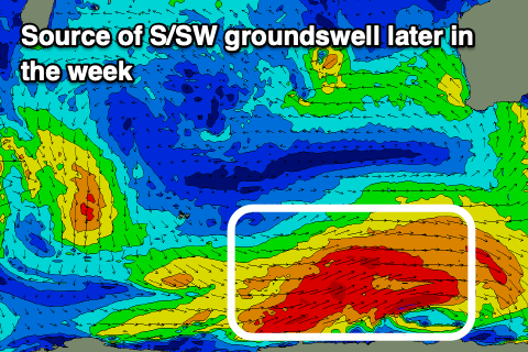
- Larger S/SW groundswell building Fri, peaking later, easing Sat
- Strong E/SE tending S/SE winds Fri/Sat
Recap
Yesterday was fun and easing back from 3-4ft across the South West with little waves holding in across the metro locations, smaller today. A reinforcing mid-period SW swell should build to 4ft this afternoon but with strengthening S/SE winds. The metro locations are still 1-1.5ft and nice and clean.
This weekend and next week (Mar 29 - Apr 4)
This afternoon’s small lift in swell will back off into tomorrow and today’s strengthening S/SE winds thanks to a trough sliding in from the west will shift more SE and easing, evening tending E/SE at times.
The South West magnets should come in around 3ft+ with tiny waves to the north.
Come Sunday, weaker E/SE offshore winds are due and a weak, polar front that’s currently south-west of us should produce a small mid-period S/SW swell to 3-4ft through the day as the metro locations remain tiny.
Into early next week, a series of strengthening polar fronts to our south-west will generate fetches of gale to severe-gale W/NW winds that will be aimed mostly away from us, but we should see some small energy spreading radially up and into us Tuesday.

Margaret River will be the main beneficiary and mostly the south magnets with inconsistent 4ft sets due, tiny to the north, easing Wednesday.
Unfortunately E’ly winds on Monday morning will shift strong S’ly into Tuesday as a trough moves through, shifting SE through Wednesday.
Now as the S/SW swell eases Wednesday, some fresh mid-period S/SW swell is due, generated by a strengthening polar front projecting up towards us Sunday/Monday.
A fetch of strong to gale-force S/SW winds should produce a moderate + sized S/SW swell for Wednesday afternoon and Thursday morning in the 6ft range across the South West with 2ft sets to the north.
Of greater significance is the stronger polar low firing up on the tail of the initial system, generating a larger S/SW groundswell for later Friday/Saturday to 6ft+ in the South West with better, offshore winds likely later week. More on this Monday. Have a great weekend!

