Make the most of the coming days
Western Australian forecast by Craig Brokensha (issued Monday March 24th)
Best Days: Today, tomorrow (protected spots South West), Wednesday morning in the South West
Features of the Forecast (tl;dr)
- Large mix of SW swells buiding this afternoon, peaking overnight, easing tomorrow and further Wed
- Variable offshore winds to the north tomorrow AM, strong S/SE-SE in the South West, increasing through the afternoon
- Fresh SE tending E/SE winds Wed AM ahead of sea breezes
- Small Thu with light E tending S/SW winds
- Small mid-period SW swell Fri with strengthening S/SE winds
- Easing swell Sat with strong, morning E/SE-SE winds
Recap
Saturday started on the small side of the coin with clean conditions that were best in the South West. Through the afternoon a new mix of swells built but with average, windy conditions, easing back yesterday from 4-6ft with small to tiny options to the north.
This morning the swell remained small to tiny across Perth and Mandurah while a new pulse of mid-period and groundswell are building across the South West with sets to 6ft under offshore winds. A larger groundswell is due through the afternoon/evening, discussed below.
This week and weekend (Mar 25 - 30)
The coming forecast period revolves around the large mix of mid-period SW energy and groundswell due into this afternoon and tomorrow morning.
As touched on in Friday’s notes, a strong low that formed south-east of South Africa generated a great fetch of severe-gale to at times, storm-force winds while pushing east. The low weakened once projecting slightly east-northeast towards us, with the mix of swells due to build today and reach at least 8ft if not 8-10ft by dark in the South West with 2-3ft waves in Mandurah and 2ft+ sets across Perth.
A peak is due through the evening before easing back into tomorrow from a similar if not slightly smaller range. The South West is likely to be mostly 8ft with 2-3ft sets in Mandurah and 2ft+ waves across Perth.
Local winds will be best around Perth and Mandurah and light offshore while Margs looks less than ideal thanks to a strong S/SE breeze that may tend SE in certain areas for short periods of time.

Wednesday will a bit better for the South West with a gusty SE tending E/SE breeze through the morning but smaller surf to 4-5ft with 1-2ft leftovers to the north.
Thursday looks super clean but only small.
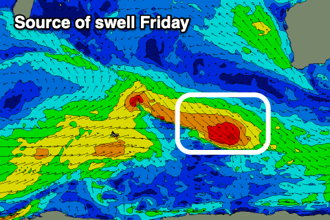
Into Friday, a very small lift in mid-period SW swell is due, generated by a small frontal system tracking east-southeast through our swell window, generating a fetch of W/NW gales. It might generate a small 4ft pulse for the South West with nothing of note to the north, fading Saturday.
Unfortunately a trough will bring strengthening S/SE winds Friday with strong E/SE-SE winds for Saturday as it eases.
Longer term there’s still nothing major standing out into the end of the month and start of April, but we’ll have a closer look at this on Wednesday.

