Plenty of quality surf days ahead

Western Australian forecast by Craig Brokensha (issued Wednesday March 19th)
Best Days: Tomorrow morning, Sunday morning, Monday morning, Tuesday morning, Wednesday morning in the South West
Features of the Forecast (tl;dr)
- Moderate + sized mid-period SW swell for tomorrow (undersized early) with E tending E/NE winds ahead of sea breezes
- Easing swell Fri with gusty S/SE-SE winds
- Moderate sized mix of swells for Sat PM with mod-fresh S/SE-SE tending S/SW winds
- Easing swell Sun with strong S/SE winds
- Large mix of SW swells building Mon PM with E/SE tending S/SW winds
- Easing swell Tue with SE winds in the South West through the AM, E/NE to the north
- Smaller Wed with morning E/SE winds
Recap
The surf backed off through yesterday with clean conditions across most locations and sets to 3-4ft in the South West.
Today the surf was less than ideal with cross-shore winds and nowhere of any real quality as a new SW groundswell filled in.
This week and next (Mar 20 - 28)
Tomorrow will be the best of the coming period thanks to the arrival of a moderate + sized mid-period SW swell arriving under a light E’ly tending E/NE breeze. This will create great conditions across all locations before sea breezes kick in, and we should see the South West building to 6ft on the sets, 2ft Mandurah and 1-2ft Perth.
Make the most of the morning ahead of strong sea breezes and then less favourable S/SE-SE winds into Friday morning as the swell backs off.
Moving into the weekend and our mix of mid-period SW and slightly better S/SW groundswell is due into Saturday afternoon, generated by a relatively weak but late strengthening low south-west of us over the coming days.
The fetch generating the S/SW component looks strongest and should reveal the most size into later Saturday and Sunday morning for the South West, peaking at 4-6ft with small 1-2ft waves max across metro regions.
Winds are tricky and look moderate to fresh out of the S/SE-SE on Saturday morning ahead of sea breezes when the swell peaks, with Sunday coming in windy with unfavourable, strong S/SE winds.
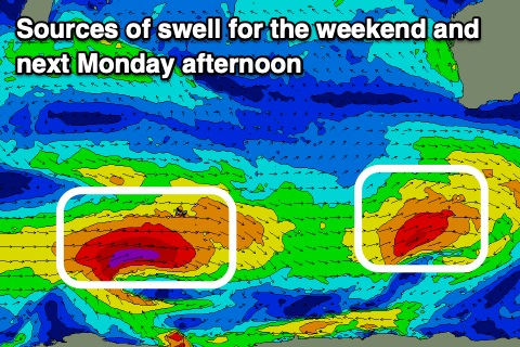
We’ll fall in between swells on Monday morning but with clean conditions thanks to an E/SE offshore. A mid-period SW swell is due through the morning along with a larger groundswell through the afternoon, generated by a strong polar low that’s currently forming south-east of South Africa.
A great fetch of severe-gale W’ly winds should move east, generating the groundswell, with the low weakening while approaching us over the weekend.
The groundswell will be least consistent, with more consistent mid-period energy generated by secondary stages of the storm projecting closer to us. Building surf to 8-10ft is due into the afternoon across the South West, 2-3ft Mandurah and 2ft Perth.
Sea breezes will spoil the new swell, with Tuesday looking OK with gusty SE winds in the South West and E/NE winds to the north along with easing levels of swell from 8ft, 2-3ft and 2ft respectively.
The rest of the week looks clean with easing levels of swell, best Wednesday before fading Thursday and Friday.
Comments
It's a lovely view, but zoom in Box cam?
The surfcam is already at max zoom. At some point I'll look to see if we can get a bigger lens, however the pinch-zoom functionality (on mobile) or full screen viewing is still pretty good (here's a snap from a few mins ago).
No worries, thanks Ben. Cracking day over there.
It really is quite incredible how much good quality surf that region gets.
Make the east coast look pretty poor really....
And proper waves!
Real waves!
Meanwhile further south i spent the entire surf duckdiving and didn't even bloody get out!! Caught a wave in the shorey so calling it a surf!
That's why its called the almost coast :)
Just the way we like it @seaslug ;-)
Yes indeed mate :)