Mixed week, best Thursday

Western Australian forecast by Craig Brokensha (issued Monday March 17th)
Best Days: Thursday ahead of sea breezes
Features of the Forecast (tl;dr)
- Easing SW swell tomorrow ahead of a new S/SW groundswell later in the day, easing Wed
- E/SE winds ahead of sea breezes tomorrow, strong S/SW-S Wed (S/SE tending S/SW to the north)
- Moderate + sized mid-period SW swell for Thu with E/SE winds ahead of sea breezes
- Easing swell Fri with gusty S/SE-SE winds
- Moderate sized mix of swells for Sat PM with strengthening S/SE tending S/SW winds
- Easing swell Sun with similar winds to Sat
Recap
The weekend started large and windy with limited options for a quality wave, best in protected spots across metro locations.
The swell backed off and cleaned up through yesterday, opening up more options across the South West, while today a good reinforcing swell is in, under strong, tricky offshore winds.
This week and weekend (Mar 18 - 23)
Our current swell is expected to ease tomorrow and an overnight trough shouldn’t impact conditions too badly, with winds swinging E/SE across the South West and E/NE to the north.
The South West will be the only decent option ahead of sea breezes and a new pulse of S/SW groundswell later in the day.
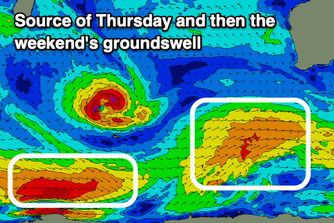
The source of this swell is a strong polar low that’s formed south-southwest of us, with a fetch of severe-gale W’ly winds kicking up a passing pulse of S/SW energy to 4-5ft+ across the South West that looks to back off from a similar size Wednesday morning.
Perth and Mandurah aren’t likely to top 1-1.5ft but conditions look poor in any case, strong from the S/SW-S across the South West and S/SE tending S/SW to the north.
Thursday looks much better thanks to winds swinging E/SE along with a fresh pulse of mid-period SW swell that will be generated by a healthy but weakening polar front that’s currently projecting up towards us. Wind speeds look below gale-force and with this we’ll see mid-period energy coming in at 6ft across the South West, 2ft Mandurah and 1-2ft in Perth.
Make the most of the clean conditions as another trough will bring a shift in winds back to the S/SE-SE on Friday as the swell eases.
Moving into the weekend and another fun pulse of mid-period SW swell is due, though not to the size of Thursday’s, with the source being a fast tracking and late intensifying frontal system to the south-west of us.
A mix of mid-period and groundswell energy are due into Saturday, peaking through the afternoon with the South West likely to reach 5-6ft with smaller 1-2ft waves in Mandurah, tiny across Perth.
Unfavourable and strengthening S/SE tending S/SW winds are due through Saturday, similar Sunday as the swell eases creating less than ideal conditions that will be best suited to protected spots (though with much less size).
Next week looks generally cleaner with a couple of moderate pulses of swell, though more on this Wednesday.
Comments
WA's long range report in SA's section?
Sorry, fixed.