Multiple strong swells inbound

Western Australian forecast by Craig Brokensha (issued Friday March 7th)
Best Days: Protected spots Sunday, Monday morning, Tuesday morning in the South West, next Saturday
Features of the Forecast (tl;dr)
- Small SW swell tomorrow with S tending stronger S/SW-SW winds
- Large, inconsistent SW groundswell building Sun, peaking through the PM, easing Mon
- Gusty S/SE winds Sun, strengthening through the day with PM S/SW winds to the north
- Fresh SE-E/SE winds Mon ahead of sea breezes (E/SE in the AM to the north)
- E/SE winds Tue AM
- Mod-large, SW groundswell building later Wed, peaking Thu
- S/SW-SW tending W winds Wed, persisting from the S/SW-SW Thu
- Large SW groundswell likely later Fri, peaking Sat AM with E/SE winds
Recap
Wednesday’s good W/SW swell eased back from 3-5ft yesterday with good conditions all morning in the South West, while Perth and Mandurah eased back from 1-2ft.
Today the surf is small to tiny and wind affected with nothing to recommend.
This weekend and next week (Mar 8 - 14)
As touched on during the week, a new pulse of SW swell due today and tomorrow morning was generated by the remnants of Tropical Cyclone Garance forming into a low south-west of us.
The fetch around it was poor for swell generation and with this we may see 3-4ft sets in the South West, easing through tomorrow with tiny waves to the north. Winds will be average and out of the S’th in any case, shifting S/SW-SW and strengthening through the day.
Our large, SW groundswell for Sunday is on track, with the strong low that generated it aiming an initial fetch of severe-gale W’ly winds towards us after forming west of the Heard Island region earlier this week.
It weakened as it projected slowly east-northeast towards us yesterday and is now breaking down South West of us, with a large, long-period groundswell due to arrive through the day Sunday, peaking into the afternoon to 10ft on the South West magnets with 3ft sets in Mandurah and 2ft+ waves across Perth.
Conditions won’t be ideal for this swell with a gusty S/SE breeze due, strengthening through the day in the South West with S/SW winds to the north as the swell kicks.
Monday is a little better with a fresh SE’ly, possibly tending E/SE at times in the South West and more reliable to the north before sea breezes kick in.
The swell looks to be easing back from 6ft to possibly 8ft across the South West, 2ft+ Mandurah and 2ft Perth with Tuesday coming in smaller but cleaner again thanks to an E/SE offshore.
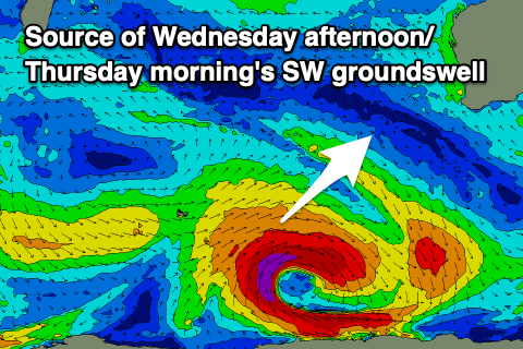
Moving into Wednesday and our secondary pulse of good SW groundswell is due to start building through the day ahead of a peak early Thursday.
The source looks to be a strengthening and expanding polar low moving across the Heard Island region on the weekend, with a good fetch of gale to severe-gale W/SW winds due to expand while the low stalls slightly on Sunday evening.
A moderate to large SW groundswell is likely with it building to a peak around 8ft (on the sets) in the South West with 2ft+ waves in Mandurah and 2ft across Perth but with what unfortunately looks like onshore winds as a trough moves in and across us on Wednesday.
Of greater significance is a possible larger SW groundswell likely later week/Saturday, produced by a similarly tracking but stronger low moving through our swell window next week. Storm-force fetches should produce a large, strong groundswell for later Friday/Saturday with better winds, but more on this Monday. Have a great weekend!