Great today, fun tomorrow

Western Australian forecast by Craig Brokensha (issued Wednesday March 5th)
Best Days: Today, tomorrow morning in the South West and Mandurah, Sunday, Monday
Features of the Forecast (tl;dr)
- Easing surf tomorrow with E/NE tending variable N winds
- Small SW groundswell for Fri PM and Sat AM with strong S-S/SW winds Fri, strong S/SE-S/SW Sun
- Large SW groundswell building Sun, peaking through the day
- Gusty S/SE-SE winds, strengthening from the S/SE Sun
- Gusty SE tending strong S/SE winds Mon with easing surf
- Possible moderate sized groundswell mid-late next week with SE winds
Recap
Yesterday was average with a weak, building mix of swells under cross-shore winds in the South West, peaky and to 1-2ft to the north.
Today we’ve got our larger and stronger pulse of W/SW swell in the water with windy but great 8ft surf in the South West, 2-3ft Mandurah and 2ft+ in Perth. The swell will ease into the afternoon as wind remain offshore in metro locations, with late afternoon sea breezes in the South West (if any).

Big and windy this morning.
This week and weekend (Mar 6 - 9)
Make the most of today as the coming days will see the surf easing tomorrow and bottoming out ahead of our next decent increase in size Sunday.
Tomorrow should be nice and clean and good across the South West with a moderate, E/NE offshore and fun surf easing back from 4-5ft with 1ft to possibly 2ft waves across metro regions.
Winds will shift more northerly through the day with only light sea breezes expected ahead of a trough and strengthening S-S/SW winds on Friday.
Our small, flukey SW groundswell for Friday afternoon and Saturday morning is still just that, with the low linked to it still not looking favourable at all for swell generation.
A kick back to 4ft may be seen in the South West with tiny waves to the north, easing Saturday under strong S/SE-S/SW winds.
The swell for Sunday is much better, with the polar low linked to it, forming to the south-east of South Africa last night.
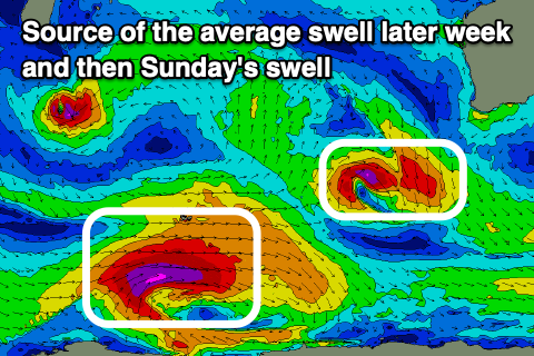
We’re due to see a great fetch of severe-gale to storm-force W’ly winds projected east today, weakening a little while projecting slightly east-northeast towards us tomorrow.
This should generate a large SW groundswell that’s expected to fill in Sunday and reach 10ft on the sets across the South West into the afternoon with 2-3ft waves in Mandurah, 2ft+ across Perth.
The swell will likely be a little undersized early but in through the morning across the South West, and fresh to strong S/SE-SE winds will favour slightly protected spots.
Monday looks to see gusty SE winds as the swell eases, backing off from 6-8ft in the South West, 2ft to occasionally 3ft Mandurah and 2ft Perth.
It looks like winds will persist out of the south-eastern quadrant most of next week, with a possible new SW groundswell mid-week. More on this Friday.