Fun surf from Wednesday, with a couple of larger pulses from the weekend

Western Australian forecast by Craig Brokensha (issued Monday February 24th)
Best Days: Wednesday morning, Friday morning in the South West and Mandurah, Saturday in the South West and Mandurah, Sunday morning, Tuesday morning
Features of the Forecast (tl;dr)
- Inconsistent, building W/SW groundswell tomorrow, peaking in the PM, easing Wed
- Moderate W-W/SW winds across the South West tomorrow, variable in the AM to the north
- New, moderate sized mid-period SW swell Wed with SE winds in the AM ahead of sea breezes
- Easing swell Thu with gusty S/SE winds, strengthening
- New, moderate sized mid-period SW swell Fri AM with S/SE-SE winds ahead of sea breeze
- Stronger SW groundswell building Sat, peaking in the PM with E/SE-SE winds ahead of sea breezes
- Easing swell Sun with E/SE-SE winds ahead of sea breezes
- Moderate + sized SW groundswell likely early next week
Recap
The weekend wasn’t great with a windy, building S/SW swell through Saturday, biggest into the afternoon, while yesterday provided fun, small waves across metro locations and semi-protected spots down south as the swell eased.
This morning a small mix of leftover swells with early light winds created OK conditions, but onshore winds quickly kicked in across metro locations, a little delayed in the South West.
This week and weekend (Feb 25 - 30)
Today’s developing onshore winds will be thanks to a trough moving in across the region, with lingering W/SW-W winds due across the South West tomorrow morning, spoiling a new, inconsistent W/SW groundswell that’s due to build through the day.
Variable winds are due to the north but the bulk of the swell isn’t expected until the afternoon unfortunately.
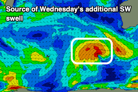
Wednesday morning looks like a better bet as winds shift around to the SE through the morning along with slowly easing levels of groundswell, but some fun, new mid-period SW swell should be in the water generated by a healthy, broad frontal progression that’s currently south-west of us.
This should maintain 4-6ft surf on Wednesday in the South West with 2ft sets across Mandurah and 1-2ft waves in Perth. The swell should ease Thursday as less favourable S/SE winds kick in, while later in the day but more so Friday, a new pulse of mid-period SW swell is due.
The source of this swell will be a strengthening but slightly less favourable frontal system firing up to our south-west mid-week, with 4-5ft+ waves due to continue in the South West, 1-2ft Mandurah though only 1-1.5ft in Perth.
A slight improvement in conditions are expected on Friday with a S/SE-SE offshore in the morning ahead of strong sea breezes.

Now, come Saturday, a third and final pulse of stronger SW groundswell is due to fill in, generated by a strong but tight low forming south-west of us Thursday evening. A fetch of severe-gale W/NW winds should kick up a larger increase in size to 6ft to occasionally 8ft across the South West through the day, 2ft+ in Mandurah after lunch and 2ft across Perth.
Morning ESE-SE winds are due ahead of sea breezes with easing surf Sunday under light E/SE-SE winds again.
There’s a good chance for another strong pulse of SW groundswell for early next week with more favourable winds. More on this Wednesday and Friday.