Downgrade in swell early next week but with more favourable winds

Western Australian forecast by Craig Brokensha (issued Friday February 14th)
Best Days: South West magnets tomorrow morning, the South West Monday (protected spots arvo), Tuesday
Features of the Forecast (tl;dr)
- Small mid-period SW swell tomorrow, easing Sun
- Mod-fresh E-E/NE winds tomorrow ahead of sea breezes from about midday
- Smaller Sun with E/NE tending SW winds
- Moderate + sized W/SW-SW groundswell building Mon, peaking in the PM
- Gusty E/SE tending stronger S/SE winds in the South West with sea breezes to the north
- Easing swell Tue with gusty E/SE winds lasting most of the day
- Smaller Wed
- Moderate sized SW groundswell likely later next week but with S/SW winds
Recap
The surf was average and weak yesterday, fading across all locations with nothing of real quality or size.
This morning we’ve got a small bump in swell with improving conditions across all locations thanks to developing offshore winds. The South West is the pick though with small to tiny waves further north.
This weekend and next week (Feb 15 - 21)
Today’s small lift in mid-period SW swell is due to hold tomorrow with inconsistent 3ft tot occasionally 4ft waves on the South West magnets, 1-1.5ft to the north and with a favourable E/NE offshore.
Winds are due to hold out of the E/NE tomorrow morning until about midday before sea breezes start to kick in. Hit the South West magnets for a wave.
Sunday will also be clean early but smaller and weaker.
We then look at the swell for Monday and unfortunately the low linked to it has been downgraded while its structure has been affected adversely as well.
The source is still tropical, with the remnants of Severe Tropical Vince currently dipping south through the Indian Ocean into the westerly storm track.
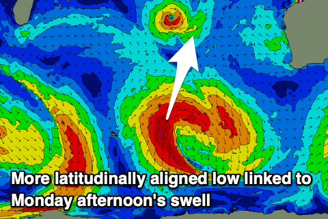
The low is now due to be more latitudinal with the bulk of the fetch aimed towards Indonesia, with sideband energy for our regions.
The fetch strength also looks downgraded and back to severe-gale but we should still see a moderate + sized, W/SW-SW groundswell for Monday, building into the afternoon and peaking after lunch/into the evening.
The South West should reach 6ft+ with Mandurah pushing to 2ft+ with 2ft sets in Perth after lunch but with fresh E/SE tending strong S/SE winds. Remember the morning will be smaller.
Tuesday will be fun as the swell eases with fresh E/SE winds, possibly holding all day in the South West, with sea breezes likely in Perth. Easing 5ft sets are due in the South West, 1-2ft Mandurah and 1-1.5ft Perth.
The middle of the week will be small to tiny while a new SW groundswell may be seen into Friday from a healthy polar frontal progression moving across the Heard Island region early next week.
A moderate sized swell is likely Friday but winds might be onshore out of the S/SW. More on this Monday. Have a great weekend!