One last, large swell to capitalise on

Western Australian forecast by Craig Brokensha (issued Friday January 17th)
Best Days: Tomorrow morning, Sunday morning, Monday morning
Features of the Forecast (tl;dr)
- Large W/SW groundswell tomorrow with light S/SE-SE winds in the South West ahead of strong sea breezes, SE to the north in the AM
- Large, easing swell Sun with E/SE winds ahead of strong sea breezes
- Smaller Mon with light E/SE winds in the South West, E/NE to the north ahead of strong sea breezes
- Small Tue with E/NE winds to the north and S/SE winds to the south
Recap
Yesterday was great with easing 5-6ft sets across the South West, 2-3ft waves in Mandurah and 2ft sets across Perth under offshore winds, while today a trough brought early variable winds to the Margaret River region which have since freshened out of the S/SW. Winds are still light across Perth and Mandurah but will increase through the day out of the N/NW then W.
This weekend and next week (Jan 18 - 24)
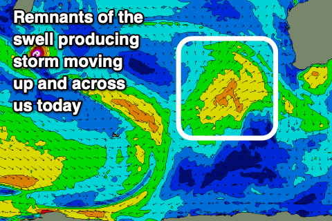
Today’s increasing onshore wind are thanks to the remnants of our large, swell producing frontal progression moving in from the west, across us.
This progression formed to the south-east of South Africa earlier this week and has been generating a great, slow moving fetch of gale to severe-gale W/SW winds while projecting slowly east and then north-east towards us.
We should see the swell peaking in the 10-12ft+ range across the South West tomorrow, 3-4ft Mandurah and 2-3ft Perth with improving winds following today’s change.
The South West looks to see light S/SE-SE winds, similar and SE to the north ahead of strong sea breezes. The light winds around Margaret River will result in lumpy conditions across the exposed reefs with cleaner options in more sheltered areas.
Sunday looks great as winds swing more E/SE across all locations through the morning along with large easing surf from the 8ft range in the South West, 2-3ft Mandurah and 2ft+ Perth.
Into next week the swell will continue to ease under a light E/SE offshore, E/NE to the north ahead of strong sea breezes. Margs should ease back from 4-5ft+ with smaller 1-2ft leftovers to the north.
Now, the rest of next week looks small to tiny with no major swell generating systems due to fire up within our close to medium-range swell windows.
Instead a deepening tropical depression off our north-west looks to track south-west into the Indian Ocean though not be favourable for swell generation for our coasts at this stage.
Otherwise a relatively weak frontal progression may bring some new SW swell next weekend but with dicey winds as the remnants of the tropical system moves across us. More on this Monday. Have a great weekend!