Easing weekend with some good new swell next week but with dicey winds

Western Australian Forecast by Craig Brokensha (issued Friday December 20th)
Best Days: This morning, Sunday morning in the South West, protected spots Wednesday and Thursday mornings
Features of the Forecast (tl;dr)
- Easing swell tomorrow with gusty S/SE winds (lighter to the north) ahead of strong sea breezes
- Small-mod sized, inconsistent W/SW groundswell building Sun PM, easing slowly Mon
- Gusty E/SE winds Sun AM ahead of strong sea breezes, light SE tending S/SW-SW Mon
- Large W/SW groundswell building later Tue, peaking Wed with strong S/SE winds Tue (S/SW to the north in the PM), strong S/SE tending S/SW Wed
- Easing swell Thu/Fri with S/SE-S/SW winds
Recap
Yesterday was windy and choppy across most coasts with a drop in swell back to 6ft across the South West while Mandurah held 2-3ft with 2ft+ waves across Perth.
Today the swell has filled in better with clean 6-8ft surf in the South West with 3ft sets across Mandurah and 2ft waves across Perth.

Strong lines this morning
This weekend and next week (Dec 21 - 27)
The current mix of large swells are due to ease into the weekend and winds will go less favourable out of the S/SE across all locations tomorrow, gusty in the South West and lighter to the north ahead of strong sea breezes.
Sunday will come in cleaner across the South West with a new, long-range W/SW groundswell due to fill in during the day, providing 4-6ft sets into the afternoon while Mandurah persists at 1-2ft with 1.5ft waves in Perth.
Gusty E/SE winds should create clean conditions before sea breezes kick in right when the swell peaks, with Monday likely to ease from a similar size under light SE winds ahead of strong S/SW-SW sea breezes.
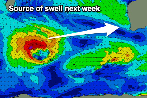
We then look to our large mix of groundswell and mid-period energy due into the middle of the week, with the frontal progression linked to it now traversing the southern Indian Ocean. It’s currently south-east of South Africa with a low producing W/SW gales that will weaken over the coming days as the system moves closer towards us while broadening.
Size wise, the swell looks to build Tuesday afternoon along with strong S/SE winds (S/SW to the north), peaking Wednesday to 8ft to occasionally 10ft on the sets across the South West with 2-3ft waves in Mandurah and 2ft+ surf across Perth.
Winds will remain an issue though and be gusty out of the S/SE on Wednesday morning, shifting strong S/SW through the day, similar Thursday as the swell starts to ease.
Friday looks dicey as well with some reinforcing mid-period S/SW swell, cleaner next Saturday but smaller.
Longer term a new SW swell is due into Saturday afternoon/Sunday but the models diverge on the strength of the swell generating system, with EC having it much weaker so for now lets set our expectations on the lower end of the scale. Have a great weekend!