Large swell today, easing into the rest of the week
Western Australian Forecast by Craig Brokensha (issued Monday December 9th)
Best Days: Keen surfers Friday, beaches Saturday morning, keen surfers Tuesday and Wednesday mornings
Features of the Forecast (tl;dr)
- Large W/SW groundswell peaking later this afternoon/evening, easing slowly tomorrow, smaller Wed
- Fresh to strong E/SE-SE winds (SE to the north) ahead of sea breezes tomorrow
- Moderate E-SE-E winds (E/NE to the north) Wed ahead of sea breezes
- Small reinforcing mid-period SW swell Thu with S/SE tending S-S/SW winds
- Easing surf Fri with S/SE tending S/SW winds (NE tending NW to the north)
- Small-mod sized W/SW swell building Sat, easing Sun but with moderate S/SW-SW winds Sat, stronger W/SW-SW Sun
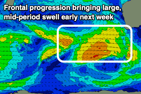
- Large mid-period W/SW swell building Mon with SW winds (S/SE-SE to the north in the AM)
- Easing swell Tue with E/SE-SE winds ahead of sea breezes
Recap
The South West was the pick of the weekend with easing surf from Friday under offshore winds, small to tiny to the north.
Today we’ve got our large, long-period W/SW groundswell on the build with the South West increasing from 3-4ft early this morning in the South West, 1-2ft to the north. Sets are now 6ft+ in the South West with strong cross-shore winds and more size to come.

A bit of size mid-morning (note the surfer)
This week and weekend (Dec 10 - 15)
The coming period mostly revolves around the large W/SW groundswell that’s currently building across the region.
We should see it reaching a peak later today to 10ft to occasionally 12ft across the South West with 3-4ft sets in Mandurah and 3ft waves across Perth, easing back from 10ft, 3ft and 2-3ft respectively on the sets tomorrow morning.
Conditions will be windy but semi-clean tomorrow with a strong E/SE-SE offshore in the South West, weaker and more SE to the north, while Wednesday looks best but smallest with a weaker E/SE-E offshore (E/NE to the north) ahead of sea breezes.
Into Thursday, winds look to revert back to the S/SE across the state along with a small, easing reinforcing mid-period SW swell that’s due to arrive Wednesday afternoon.
The source is a fetch of W/NW winds to our south-west today and this only looks to maintain 4ft+ waves in the South West through the morning, easing through the day and with tiny waves to the north.
Into the weekend, a small pulse of mid-period W/SW swell is due, generated by a distant frontal system that’s currently south-east of Madagascar.

This doesn’t look to provide any major size and winds look to swing onshore in any case thanks to an approaching mid-latitude frontal progression. S/SW-SW winds on Saturday look to strengthen from the W/SW-SW through Sunday, with some large, mid-period W/SW swell due to follow early next week (Monday).
At this stage winds look to improve for Perth and Mandurah on Monday as the frontal progression clears with lingering S/SW-SW winds in the South West, cleaner Tuesday as the size starts to ease.
We may see further larger pulses of swell with a bit more quality later in the week as secondary frontal activity fires up in our swell window, but more on this Wednesday.

