Fun run of surf ahead, large early next week
Western Australian Forecast by Craig Brokensha (issued Wednesday December 4th)
Best Days: Tomorrow morning, Friday morning, Saturday morning in the South West, protected spots later Monday and Tuesday, Wednesday morning
Features of the Forecast (tl;dr)
- Easing swell tomorrow with moderate to fresh E/SE-SE winds ahead of sea breezes (S/SE-SE to the north in the AM)
- Moderate sized mix of W/SW and SW swells Fri AM with similar winds to Thu
- Easing swell Sat with fresh E/SE winds ahead of sea breezes
- Large W/SW groundswell building Mon, peaking later easing Tue
- Strong S/SE winds Mon/Tue
- Easing swell Wed with light E tending S/SW winds
Recap
Fresh to strong onshore winds have made a mess of the surf the last couple of days along with slowly easing levels of swell.
Today the swell is smaller again and onshore winds are persisting but easing with fun options across the metro beaches.
This week and next (Dec 5 - 13)
Our improvement in local winds across all locations is still on the cards for tomorrow, as is the drop in energy back to 4-5ft in the South West, with inconsistent 2ft sets across Perth and Mandurah.

An E/SE-SE wind will create clean conditions in the South West with winds more S/SE-SE to the north, favouring slightly more protected beaches which will be a little smaller.
Come Friday, reinforcing pulses of mid-period W/SW and SW swell are due, generated by healthy fetches of W/SW and SW winds through our swell window Wednesday and today. This is additional frontal activity on the backside of the low that brought Monday’s swell and should boost the South West magnets to 5-6ft on the sets and maintain 2ft waves across Perth and Mandurah before easing into the afternoon and further Saturday.
Winds look similar to Thursday on Friday, with better E/SE winds due Saturday as the swell fades. Sunday will be smaller again with a fresh E/SE-SE breeze.
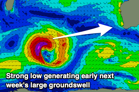
Moving into next week, we’ve got our large W/SW groundswell due on Monday, with a strong low that’s forecast to form south-east of South Africa this evening currently on track.
The low is forecast to generate a great fetch of severe-gale to storm-force W/SW winds in our western swell window tomorrow and Friday morning before breaking down into Saturday.

We should see the swell arrive Monday morning and build strongly to 10ft+ across the South West by the late afternoon/evening, 3ft+ Mandurah and 2-3ft Perth, easing back from 10ft, 3ft and 2-3ft respectively on Tuesday.
Unfortunately strong S/SE winds will blow all swell which will limit options to protected spots, while Wednesday looks great with a lighter E’ly offshore as the swell drops.
Longer term there’s not much to work with at all so make the most of the coming fun days of surf.

