Fun sized swells with slightly better winds
Western Australian Forecast by Craig Brokensha (issued Monday October 21st)
Best Days: Wednesday morning, Thursday morning, Sunday morning, Monday and Tuesday mornings
Features of the Forecast (tl;dr)
- Moderate + sized mid-period SW swell tomorrow with a stronger increase in energy on Wed
- Strong but easing W/SW winds tomorrow (possibly variable early Perth)
- S/SE-SE tending S/SW winds across the South West Wed, E/SE to the north in the AM
- Easing swell Thu with E/SE-SE tending S/SW winds
- Slow increase in SW swell Fri, with a better increase in moderate sized, mid-period SW swell Sat PM and Sun AM
- Fresh S/SE tending S/SW winds Sat, SE tending S/SW Sun
- SE winds Mon and Tue AM in the South West, E/NE to the north
Recap
Persistent onshore winds created poor conditions across the South West all weekend, bumpy but doable in Mandurah Saturday morning, while Perth offered the cleanest conditions.
Saturday was a fun, peaky 2-3ft with smaller 2ft waves into yesterday with clean conditions in both Mandurah/Perth.
Today the South West remains onshore while Perth and Mandurah have early light winds and fun levels of swell. Winds have since shifted onshore across the South West.
This week and weekend (Oct 22 - 27)
The coming period provides a respite from the persistent onshore flow across the South West though no real true offshore with strength is expected, so the expectations have to be lowered in regards to perfect conditions.
A healthy but weakening frontal progression is currently projecting towards us and this will bring an increase in mid-period swell tomorrow along with the better groundswell Wednesday, generated by the earlier, stronger stages of the progression.
Winds look strong from the W/SW tomorrow, easing through the day and the chance for variable offshore winds in and around Perth is 50/50.

Wednesday looks better as the progression clears east, allowing winds to ease and tend E/SE across the metro locations with light S/SE-SE winds in the South West.
Size wise the South West looks to still peak around 6ft+ though likely through the morning with 2-3ft waves in Mandurah and 2ft surf across Perth.
Thursday looks cleaner across the South West as the swell starts to ease under a light E/SE-SE breeze ahead of sea breezes.
From Friday but more so the weekend we should see building levels of mid-period SW swell energy as a stream of frontal systems move in through the Southern Ocean.
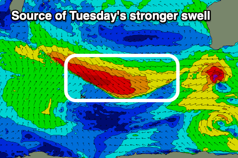
Multiple embedded fronts should generate winds mostly below gale-force, but one stronger system over the weekend should produce pre-frontal W/NW gales. This will generate the best pulse of energy for Tuesday week, but ahead of this the activity before it should produce building levels of swell Friday, peaking Saturday afternoon through Sunday.

It looks like the South West will reach the 6ft range with 2ft waves in Mandurah, 1-2ft across Perth, while Tuesday’s swell looks better and more so to 6ft+, 2ft+ and 1-2ft respectively.
Local winds on the weekend look S/SE tending S/SW on Saturday across all locations, more SE on Sunday morning and then SE through Monday/Tuesday in the South West, E/NE to the north.
Beyond this, the longer term outlook is slow as a big high moves in so try and make the most of the coming windows of better winds for the South West and the metro locations.

