Average weekend, fun early next week
Western Australian Forecast by Craig Brokensha (issued Friday October 20th)
Best Days: Keen surfers early Sunday Perth/Mandurah, Wednesday morning, Thursday morning
Features of the Forecast (tl;dr)
- Moderate + sized mix of SW swells building tomorrow PM, holding Sun AM, then easing
- Fresh NW winds tomorrow (lighter N/NE early Perth/Mandurah)
- Strengthening N/NE winds Sun, early light N/NE-NE Perth/Mandurah
- Fresh SW winds Mon
- Strong W winds with building levels of mid-period swell
- Moderate + sized SW swell for Wed, peaking in the PM
- E/SE tending SW winds Wed, E/NE tending NW winds Thu
Recap
Perth and Mandurah offered the best waves yesterday and a little less swell and light morning winds, onshore and poor across the South West.
This morning the swell is steady but winds are average across all locations, though still doable in Perth and Mandurah for the keen.
This weekend and next week (Oct 21 - 25)
There’s no change to the weekend outlook with a mix of mid-period and long-range groundswell due to fill in.

The mid-period energy looks smallest tomorrow morning while a stronger mix of swells are due into the afternoon tomorrow, though Sunday will offer the cleanest conditions.
The long-range groundswell was generated early week by a great fetch of gales to the south-east of South Africa, while some additional SW energy has been generated last night to our south-west.
We should see Margs peaking to 6ft+ across the South West with 2ft+ sets in Mandurah and 2ft waves across Perth tomorrow afternoon and Sunday morning.
Fresh NW winds are due tomorrow, creating poor conditions, though Perth and Mandurah should see early N/NE breezes, with Sunday seeing strengthening N/NW winds, shifting strong W/SW into the late afternoon. Perth and Mandurah are then due to see early N/NE-NE winds creating OK, peaky conditions.

Into Monday, lingering SW winds are due across all locations in the wake of Sunday’s change, strong W on Tuesday as another weak, mid-latitude front moves into us.
This will bring some new mid-period swell but to no major size, while Wednesday is still looking the goods with a better pulse of mid-period SW swell.
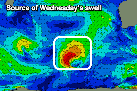
The earlier stages of the front moving through Tuesday should generate a fetch of strong to gale-force SW winds through Sunday, projecting ideally towards us. This will produce moderate + sized surf with a peak due Wednesday afternoon to 6ft+ in the South West (a touch smaller early), 2ft+ Mandurah and 2ft across Perth.
Winds will swing E/SE as a high moves in, with afternoon sea breezes expected, then E/NE offshores Thursday morning as the swell eases.
Following this the outlook is slower so try and work around the windows on Wednesday/Thursday mornings. Have a great weekend!

