Average run for the South West
Western Australian Forecast by Craig Brokensha (issued Wednesday October 16th)
Best Days: Today, Saturday/Sunday/Monday mornings Perth/Mandurah, Wednesday morning, Thursday morning
Features of the Forecast (tl;dr)
- Easing swell tomrorow with strong but easing S/SW tending W/SW winds
- Small reinforcing SW swell Fri with strengthening W/NW-NW winds (likely variable early to the north)
- Moderate sized mid-period SW swell for Sat AM, with a stronger groundswell for the afternoon and Sun AM
- Fresh to strong W/NW-NW winds Sat (variable early to the north)
- Fresh W/NW tending strong W-W/SW winds (variable early to the north)
- Slightly smaller Mon with W winds in the South West (variable early to the north)
- Strong W/SW tending S/SW winds Tue with a building mid-period SW swell, peaking Wed AM with E/SE-SE winds
- Easing swell Thu with similar winds
Recap
A strong W/SW groundswell filled in through yesterday but conditions were mostly average with dawn onshore breezes adding bumps, improving slightly through the morning as winds tended more variable across Perth and Mandurah. Margs improved into the afternoon but not enough to provide anything memorable.
This morning is the pick if it across the metro locations with surf still to 3ft in Perth with offshore winds, a little ruffled and to 4ft across Mandurah while the South West is still large but under the influence of strengthening north-east winds, favouring selected spots. Make the most of this morning as winds will shift more N/NW into the afternoon (lighter to the south).

Good surf this morning
This week and next (Oct 17 - 25)
As touched on above, make the most of today as a trough will bring poor S/SW tending W/SW winds tomorrow along with easing levels of W/SW swell across all regions, followed then by a persistent run of onshore winds through the weekend and next week.
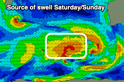
This will be thanks to weak but persistent frontal activity push up and towards us from the Southern Ocean, bringing with it moderate sized pulses mid-period swell, with a groundswell in the mix for Saturday afternoon and Sunday morning.
The source of this inconsistent groundswell was a distant fetch of polar gales to the west of the Heard Island region on Monday, and overall the surf looks to peak in the 6ft to occasionally 8ft range across Margs later Saturday/Sunday with 2ft+ waves across Mandurah, 2ft in Perth.
Winds on Friday look to strengthen from the W/NW-NW (possibly variable early Perth/Mandurah), similar Saturday with a little less strength to the W/NW-NW flow.

Sunday will unfortunately see wind swing from a fresh W/NW’ly to a strong W-W/SW breeze (variable again early Perth/Mandurah), with smaller surf Monday but with straight W winds in the South West. Perth and Mandurah will be clean again in the morning but small surf to 1-2ft and 2ft respectively.
One final day of onshore winds is likely on Tuesday before a high moves in on Wednesday along with some moderate + sized mid-period SW swell generated by the final low moving through Tuesday.
The models diverge a little regarding the timing and strength of this system but good 6ft+ waves are likely due in Margs, 2ft+ Mandurah and 2ft Perth with a morning E/SE-SE offshore, similar Thursday as the swell eases.
Longer term there’s nothing too major on the cards so make the most of the coming windows and today.

