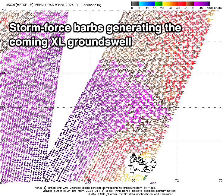
XL swell tomorrow with light winds
Western Australian Forecast by Craig Brokensha (issued Monday October 14th)
Best Days: Tomorrow all locations, early Wednesday, Friday morning Perth and Mandurah, Saturday/Sunday mornings Perth/Mandurah
Features of the Forecast (tl;dr)
- XL, W/SW groundswell showing later today, peaking tomorrow AM, easing into Wed
- Moderaet W/SW tending variable W/NW winds across the South West, variable to the north, tending W/SW-SW into the PM
- Early NE tending N/NE then stronger NW winds in Perth/Mandurah Wed, N/NE tending strong N/NW across Margs
- Strong but easing SW tending S/SW winds Thu
- Easing swell Fri with strong NW winds (lighter N/NE to the north)
- Moderate sized mid period W/SW-SW swell Sat with a new groundswell for the PM and Sun AM
- Lingering NW winds Sat in the South West, W/SW-SW on Sun (variable NE offshore to the north each morning)
Recap
The surf was generally average and bumpy on Saturday while a reinforcing SW groundswell for Sunday with offshore winds provided much better conditions. Today the remnants of the strong low linked to our incoming XL W/SW groundswell has brought onshore winds with small levels of swell.
We should see the forerunners of the groundswell arriving this afternoon ahead of the bulk of the energy tomorrow. More on this below.
This week and weekend (Oct 15 - 20)
The coming week mostly revolves around the XL, W/SW groundswell due into tomorrow and the local winds.
Since late last week and through the weekend, we’ve seen one of the strongest lows of the year moving through the Southern Ocean with satellite observations confirming a great fetch of storm-force winds being projected towards us for quite a sustained period.
This has generated a very powerful, long-period W/SW groundswell that’s due to come in the XL range tomorrow across the South West, peaking to 15-20ft during the morning with 4-5ft+ sets across Mandurah and 3-4ft waves in Perth.

Local winds will be OK but not perfect with the swell generating storm weakening further tomorrow, leaving moderate W/SW winds across the South West at dawn, easing and tending more variable W/NW through the morning/afternoon with variable morning winds around Mandurah (possibly S/SW in nature early), with variable S winds around Perth. Winds across the metro regions should shift more W/SW-SW during the day but without any strength. This should create good to great conditions with the strength of the swell.
Wednesday’s window of clean conditions now looks limited with an approaching mid-latitude front expected to move in quickly, bringing NE tending N/NE and then stronger N/NW winds across the metro locations with early N/NE tending stronger N-N/NW winds in the South West.
Size wise the South West should still be 10ft+ with 3-4ft waves in Mandurah, 2-3ft across Perth with Thursday coming in smaller along with strong but easing S/SW tending SW winds.
There should also be some moderate + sized mid-period swell in the mix on Thursday generated by the mid-latitude low moving across us, easing Friday with strong NW winds (lighter and more N/NE early across Perth/Mandurah).
Into the weekend, a mix of moderate + sized mid-period and groundswell energy from the W/SW-SW are due, generated by a polar low that’s currently south-east of South Africa. This low will project a fetch of W/SW gales slowly towards us, with the frontal system racing off ahead of it and generating some mid-period energy that’s due to be in the water Saturday morning ahead of the groundswell component into the late afternoon/Sunday.
Size wise the mid-period energy looks to come in around 4-5ft+ across the South West, small and to 1-2ft to the north and with NW winds on Saturday (lighter N/NE-NE to the north).
Sunday looks a touch stronger but less consistent and more to 5-6ft in the South West, 1-2ft to the north again.
Winds will remain W/SW-SW in the South West unfortunately on Sunday with lighter, variable offshore winds to the north.
Longer term, persistent weak frontal activity will generate plenty of moderate + sized mid-period swell for next week but with lingering onshore winds for the South West. More on this Wednesday.

