Good to great run of surf lining up
Western Australian Surf Forecast by Craig Brokensha (issued Friday June 28th)
Best Days: Today protected spots, tomorrow morning all locations (South West all day), Sunday in the South West for the keen, protected spots Tuesday, Wednesday, Thursday, Friday morning
Features of the Forecast (tl;dr)
- Easing S/SW and W/SW swells tomorrow with an inconsistent SW groundswell in the mix
- Moderate E/SE tending SE winds tomorrow
- Smaller Sun with E/NE tending variable winds
- Inconsistent SW groundswell Mon with strengthening N/NE tending N-N/NW winds
- Large W/SW groundswell building Tue, peaking overnight, easing Wed
- Gusty S/SE winds Tue, E-E/NE Wed
- Large reinforcing SW groundswell Thu PM with gusty E/NE winds, easing Fri with E/NE tending NE winds
Recap
Our funky day of weather, swell and improving conditions was just that with a moderate to large sized pulse of W’ly swell kicking to 6-8ft across the South West with generally peaky conditions and close-spaced sets.
Mandurah and Perth both improved through the day with building size and early N winds, swinging offshore, creating pumping waves into the afternoon with consistent 3ft waves.
Today the swell is on the ease, mixed in with some background groundswell and conditions clean across most spots with strengthening offshore winds.
Since, the swell has kicked from the south across the South West from what looks to be a fetch of strong winds feeding into the bottom of the low moving across us. It's low in period though.
This weekend and next week (Jun 29 - Jul 5)
Looking at the weekend ahead and we’ve got great conditions due across all locations with today’s surge of local S/SW swell easing as some background groundswell provides fun surf in the South West, small to tiny to the north.
A drop back to the 3-5ft range is due in the South West tomorrow, with fading 2ft sets to the north, smaller Sunday. E/SE tending SE winds are due tomorrow with E/NE tending variable winds into Sunday.

Monday looks to be average as winds deteriorate and some small background SW groundswell pads out exposed breaks, with strengthening N/NE tending N/NW winds due.
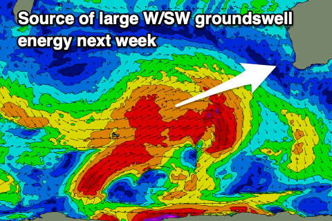
This strengthening breeze will be associated with the head of a strong Southern Ocean frontal progression moving in from the west, and with this we’re expected to see multiple pulses of large W/SW groundswell from Tuesday through most of next week.
Overall the progression is strong but a little disjointed and this will likely prevent things getting to the XL size range but we’ll see great conditions with the storm activity staying at arms length to us.
Back to back bursts of W/SW gales should generate a large W/SW groundswell for Tuesday afternoon, reaching the 10ft+ range across the South West with 3ft sets in Mandurah and 2-3ft waves across Perth, easing slowly Wednesday.
Winds should revert back to the S/SE on Tuesday, as Monday’s approaching trough clears to the east, with great E-E/NE winds due on Wednesday.

Another large, reinforcing SW groundswell is likely later week from a trailing front generating gale to severe-gale W/NW winds to our south-west early next week. The size of this swell looks to be again in the 10ft+ range for Thursday afternoon, easing back through Friday.
Winds look great Thursday and gusty from the E/NE with Friday seeing NE tending N/NE winds as the swell eases.
Longer term there’s a bit more activity and fun W/SW swell due into later next weekend, early the following week but with dicey winds. More on this Monday. Have a great weekend!

