Tricky week of winds and waves
Western Australian Surf Forecast by Craig Brokensha (issued Monday June 24th)
Best Days: Today, tomorrow across the South West, Thursday (afternoon Perth and Mandurah), Friday morning protected spots, Saturday in the South West
Features of the Forecast (tl;dr)
- Easing W/SW swell tomorrow with an inconsistent SW groundswell filling in through the PM
- Moderate E/NE tending fresher NE winds tomorrow
- Easing mix of swells Wed with early strong N/NE tending weaker W/NW winds
- Moderate sized mid-period W swell for Thu with N/NE tending E winds across the metro locations, E/NE tending E/SE across the South West
- Easing W swell and inconsistent SW groundswell Fri with strong S/SE winds
- Easing swells Sat/Sun with E/SE winds
Recap
Poor surf on Saturday with strong onshore winds and a building close-range swell, pumping yesterday across metro locations as the swell generating low cleared and winds swung offshore. It was peaky and to 3ft while Margs improved across protected spots with surf to 8ft+.
Today is a bit cleaner in the South West but smaller and back to 4-6ft on the sets and a little raw, cleaner and to 2ft across metro locations.

Thumping yesterday AM
This week and weekend (Jun 25 - 30)
We’ve got a much more subdued surf period ahead both wind, weather and swell wise thanks to the Indian and Southern Oceans falling relatively quiet.
We’ll see meandering mid-latitude systems angled more south to north rather than west to east and this makes for a tricky outlook with swells being bigger further north rather than the other way around.
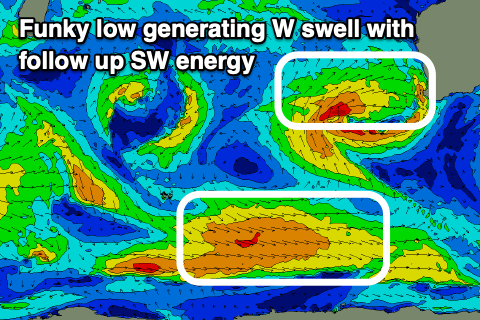
Firstly looking at tomorrow and we’ll see the current swell continuing to ease, while an inconsistent SW groundswell should take its place, generated by a strong but distant low west of the Heard Island region last week.
The South West should build to 4-6ft into the afternoon, tiny to the north and with moderate E/NE tending fresher NE winds. The swell will ease back through Wednesday along with strong N/NE tending weak W/NW on Wednesday as a trough moves through.

Into Thursday, a small to moderate sized pulse of W’ly swell is due, generated by one of the northward projecting lows, with a fetch of strong SW tending W/SW winds due to be generated in our western swell window over the coming days.
Wednesday’s change will be associated with a trough spinning off the low, but later week it’s expected to track north with the Margaret River and metro regions likely to fall under strengthening S/SE winds with NW winds further north.
Size wise, the W’ly swell from the initial stages looks to come in around 6ft in the South West, 2-3ft to the north and with N/NE tending E winds across the metro locations, E/NE tending E/SE in Margs.
Friday will then see the strengthening S/SE winds as the low moves across us, shifting back E/SE on the weekend. Size wise, the W’ly swell looks to be on the ease, mixed in with some inconsistent SW groundswell.
Longer term we’re looking at more significant Southern Ocean storm activity firing up later this week and into the weekend, generating some larger surf later next week though winds are a little unsure. We’re looking at onshore winds at the peak of the swell, cleaner as it eases but check back Wednesday for more.

