Smaller end to the week, decent early next week
Western Australian Surf Forecast by Craig Brokensha (issued Wednesday June 12th)
Best Days: Today, tomorrow morning and Friday morning in the South West, Sunday morning Perth and Mandurah, Monday and Tuesday mornings all locations
Features of the Forecast (tl;dr)
- Small S/SW swell tomorrow with E/SE-SE tending variable winds ahead of late sea breezes
- Inconsistent mid-period SW swell Fri AM, with a mid-period W/SW swell for the PM and Sat AM
- Fresh E/NE tending NE then N/NE winds Fri, fresh N/NE tending N/NW Sat
- Large sized W/SW swell for Sun PM and Mon AM
- Freshening W/SW tending SW winds Sun (E/NE to the north in the AM), E/SE tending S/SW Mon
- Smaller Tue with variable tending NW winds
Recap
Monday’s large, stormy surf backed off into yesterday and improved as the day went on as early lumpy conditions sorted themselves out in Perth and Mandurah. Fun 2-3ft waves were seen all day in Perth, a chunky and lumpy but decent 3ft in Mandurah while Margs backed off quickly from 8-10ft but with lumpy conditions persisting all day.
Today is smaller but cleaner across all locations, fun in metro locations.
This week and weekend (Jun 13 - 16)
We’ve got some fun surf due over the coming days with morning offshore winds and small to moderate swell pulses before things go a little funky into the weekend and next week.
Firstly tomorrow, a small-moderate sized mid-period S/SW swell is due across the South West, generated by a weak polar front. 4ft sets are due in the South West on the magnets, tiny elsewhere and with light E/SE-SE offshores and weak sea breezes.
Similar sized waves are due into Friday morning ahead of some inconsistent W/SW groundswell later in the day and Saturday morning, pulsing to 4-6ft across the South West with 1-1.5ft waves due in Perth and Mandurah.
Fresher E/NE winds are due Friday morning, shifting NE and then N/NE into the afternoon, with Saturday seeing trickier, fresh N/NE tending N/NW winds.
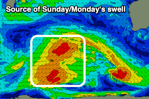
This shift in wind will be ahead of a broad strong approaching frontal system through the Southern Ocean, protruding into the Indian Ocean.

Various fetches of strong to gale-force W/SW winds should produce a large mid-period W/SW swell Sunday afternoon and Monday morning.
Good 6-8ft sets are due in the South West at the peak, 2-3ft across Mandurah and 2ft in Perth on the sets but with freshening W/SW tending SW winds in the South West, variable E/NE to the north, tending SW during the day.
Monday should see winds swing offshore from the E/SE across all locations and this is the pick of the period thanks to Tuesday being smaller but with early variable offshore tending NW winds.
Longer term, we’re looking at a strong polar frontal system projecting north-east towards us mid-week, bringing a low quality, windy increase in swell, cleaner and easing later week. Overall not great so get stuck in over the coming days.


Comments
Just wondering lately no local photos ?
No Friday report?
No 9am or lunchtime reports ? Says next update 9am but never comes ?
Is someone away /sick ?
Thanks
Jon, I somehow forgot to upload the WA forecast yesterday.
Blame it on the new baby. I wrote it but never added. Here it is.. https://www.swellnet.com/reports/forecaster-notes/western-australia/2024...
Cheers, Craig