Tricky period of winds with various swell pulses
Western Australian Surf Forecast by Craig Brokensha (issued Monday June 10th)
Best Days: Tomorrow from mid-late morning ahead of sea breezes, Wednesday/Thursday/Friday mornings in the South West for the keen, Sunday, Monday
Features of the Forecast (tl;dr)
- Easing swell tomorrow with pre-dawn W winds, tending variable during the morning ahead of sea breezes
- Smaller Wed with E/SE tending S/SW winds in the South West (E/NE-NE to the north)
- Small S/SW swell Thu with E/SE tending S/SW winds
- Inconsistent mid-period SW swell Fri AM, with a mid-period W/SW swell for the PM and Sat
- E/NE-NE tending N winds Fri, N/NE-NE tending N/NW Sat
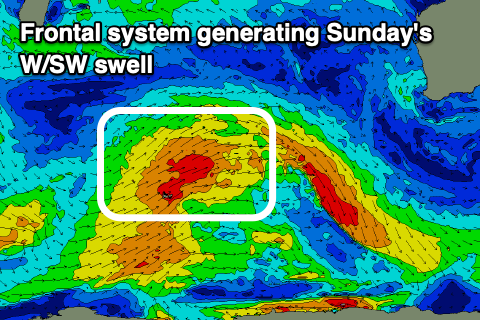
- Mod-large sized W/SW swell for later Sat, peaking Sun with N/NE tending NW winds
- Easing swell Mon with E/NE-NE tending N winds
Recap
Friday’s swell backed off into Saturday but conditions were still fun across the Perth metro locations with peaky 2-3ft sets, a little more wind affected in Mandurah, even more so down in Margs.
Yesterday an approaching front brought increasing winds and choppy conditions across all locations along with building surf which has reached the XL range this morning but with strong W’ly winds.
This week and weekend (Jun 11 - 16)
The strong, slow moving mid-latitude low linked to yesterday’s and today’s large to extra-large stormy surf is now quite broad and elongated and what that means for improving conditions across our region is not ideal.
Lingering onshore winds are due right up until dawn tomorrow, then tending variable across most locations. This means there’ll be lots of lump and wobble in the surf with easing sets from 10ft in the South West, 3ft+ Mandurah and 2-3ft Perth.
Conditions should be best later morning and into the early afternoon before onshore winds start to kick back in so there’s no rush for the early.
As touched on in Friday’s outlook, Wednesday looks clean but the swell will be small, weak and fading back from the 4ft range in the South West, small to tiny and 1-1.5ft to the north.
Thursday morning looks clean again through the morning along with a small to moderate sized pulse of mid-period S/SW swell that’s due to arrive later Wednesday.
The source is a weak flurry of polar frontal activity with surf to 4ft likely to persist across the South West, tiny to the north.
From Friday winds will start to shift more north of east as weak fronts push up towards us and then get deflected down on approach.

Background levels of groundswell are due, an initial pulse in the morning to 4ft, while a stronger long-period swell is due into the afternoon and Saturday morning more to 4-6ft. Perth and Mandurah look to remain tiny with 1-1.5ft sets later Friday but more so Saturday and with N/NE tending N/NW winds.
A larger mid-period W/SW swell is due on Sunday, generated by one of the incoming fronts with surf more to 6ft to occasionally 8ft due in the South West, 2ft to possibly 3ft in Mandurah and 2ft across Perth.
Winds will be N/NE to N/NW again, favouring selected spots, more E/NE-NE on Monday as the swell eases.
Longer term the outlook becomes quiet as the activity settles down in the Indian Ocean. With this in mind make the most of the lumpy, improving surf across metro locations tomorrow.

