Poor run of surf from Sunday into next week
Western Australian Surf Forecast by Craig Brokensha (issued Friday June 7th)
Best Days: Today, Thursday morning
Features of the Forecast (tl;dr)
- Easing W'ly swell with E/NE-NE tending NW winds in the South West, holding NE into the PM to the north
- Building mix of large stormy swells Sun PM with strengthening W/NW winds
- XL groundswell peaking Mon AM with strong W tending W/NW winds
- Easing swell Tue with strong NW tending W/NW winds
- Small, fading surf Wed with variable N/NE winds
- Moderate sized mid-period SW swell Thu with E/SE tending SW winds
Recap
Yesterday saw a building N/NW windswell across metro locations with favourable winds for northern corners, poor but becoming large down in the South West.
Today, all locations have seen improving conditions as the swell generating low cleared to the south-east, creating pumping waves in Perth, good surf across Mandurah and OK waves in the South West. Make the most of it before winds kick back up again into the weekend.

Cooking surf this morning
This weekend and next week (Jun 8 - 14)
As touched on above, today’s clean conditions and large W’ly swell will fade into the weekend as winds shift from a morning E/NE-NE breeze tomorrow, around to the NW in the South West, but remaining from the NE all day to the north.
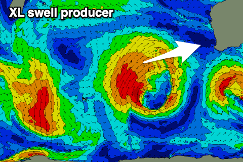
Come Sunday, winds will be strong from the W/NW, increasing further during the day as out strong, slow moving low linked to our XL swell moves in.
Also touched on in Wednesday’s notes - this low formed around the Heard Island region and has since been projecting slowly north-east towards us, generating fetches of strong to gale-force SW winds.

It’s due to weaken while moving into us, with one final punch due into Sunday afternoon/evening, bringing the stronger burst of winds.
Size wise we should see large, stormy surf developing on Sunday afternoon, with the XL groundswell peaking Monday morning to 12-15ft in the South West and 4-5ft across Perth and Mandurah along with strong W tending W/NW winds.
Unfortunately strong NW-W/NW winds will persist on Tuesday as the swell fades, more variable Wednesday and tending N/NE across most locations but with smaller, fading surf.
The South West looks to be easing from 3-4ft with tiny waves to the north. All in all a bit of waste.
The rest of the week looks slow with Thursday being the pick under morning offshore winds along with a new, moderate sized mid-period swell. Following this larger surf is on the cards for next weekend and the following Monday but winds are up for grabs. More on this Monday. Have a great weekend!


Comments
https://www.abc.net.au/news/2024-06-08/search-for-missing-surfer-at-prev...
Far out, hope for the best.