A couple of windows between large, onshore surf
Western Australian Surf Forecast by Craig Brokensha (issued Wednesday June 5th)
Best Days: Friday, Saturday morning
Features of the Forecast (tl;dr)
- Strengthening N tending N/NW winds tomorrow with a building windswell, and a large, building W swell
- Large W/SW swell Fri AM, easing with variable winds in the South West, E/SE-SE to the north
- Smaller Sat with E/NE-NE tending strong NW winds
- XL stormy surf building Sun with strong to gale-force W winds
- Easing swell Mon with strong W/NW winds
- Smaller Tue with S/SE tending S/SW winds
Recap
Everywhere offered much cleaner and better surf yesterday with easing sets from 8ft+ across the South West under a light offshore wind, 3ft Mandurah and 2-3ft in Perth.
Today was a bit smaller and with more north in the wind, though a new SW groundswell is providing quality sets across the South West and workable options (now poor with stronger winds).
This week and next (Jun 6 - 14)
We’ve got deteriorating conditions ahead of an approaching mid-latitude frontal progression with strengthening N tending N/NW winds due to whip up some local windswell tomorrow, shifting W/SW into the evening and then abating rapidly Friday.
This will be as moderate to large levels of mid-period W/SW swell fill in from the front itself, peaking Friday morning and then easing.
Sets to 10ft are still due across the South West, 3ft in Mandurah and 2-3ft in Perth and winds look to back off earlier, tending variable across the South West with E/SE tending S/SE winds to the north.

Saturday looks to see easing surf and with an early E/NE breeze that will quickly strengthen and shift NW so the window is small.
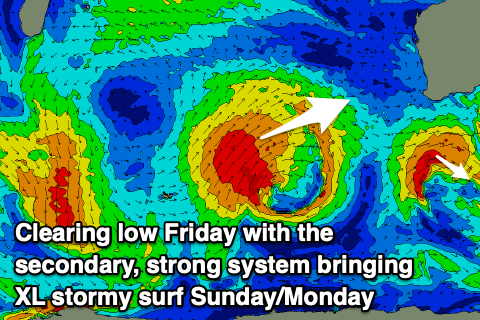
This shift in wind will be associated with the next incoming mid-latitude system and it looks to be broader, stronger and slower moving. As a result an XL, stormy W/SW groundswell is due from this system, with it building strongly later Sunday along with some localised windswell as the low pushes into us.
Strong to gale-force W’ly winds and 12-15ft surf look to leave no quality options with stormy 4-5ft waves in metro locations, easing Monday as strong W/NW winds persist.
The low is due to clear east and break down Tuesday, allowing winds to shift S/SE and we should still be seeing large surf, easing back from 6-8ft waves in the South West, 2-3ft Mandurah and 2ft Perth.
Behind this there’s plenty more swell due but local winds look to remain dicey at best. More on this Friday.

