Increasing winds and surf over the coming days
Western Australian Surf Forecast by Craig Brokensha (issued Friday May 31st)
Best Days: Desperate surfers northern corners tomorrow morning metro locations, Monday Perth and Mandurah, Tuesday
Features of the Forecast (tl;dr)
- Large surf building through the weekend, reaching XL later Sun and more so Mon AM
- Strong N/NW winds tomorrow (N/NE early Perth and Mandurah)
- Strong W/SW winds Sun
- Mod-fresh SW winds Mon AM, easing to moderate (E/SE Mandurah in AM, E/NE Perth)
- Easing swell Tue with E/NE tending N winds
- Inconsistent, mod-large SW groundswell building Wed with strengthening N winds, easing Thu
- Large to XL swells later next week and weekend but with onshore winds
Recap
Conditions were poor and onshore across all locations yesterday morning but we saw winds back off in Perth and Mandurah through the morning, creating slightly better conditions for the keen into the early to mid afternoon.
This morning conditions were better with a bit of north in the wind and smaller 2ft sets in Perth, 2-3ft across Mandurah.
This weekend and next week (Jun 1 - 7)
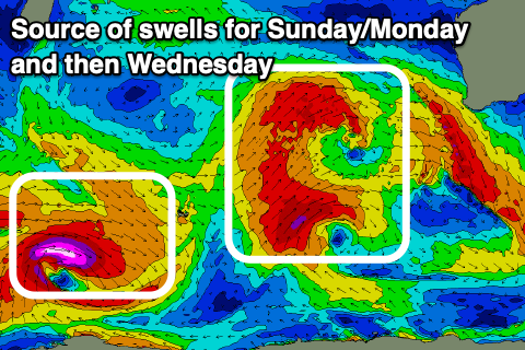
Looking at the weekend ahead, we’ve got building levels of large W/SW groundswell, with it reaching the XL range into later Sunday and Monday morning.
The source is a strong frontal progression projecting up north, through the Indian Ocean under the influence of a strong node of the Long Wave Trough.
Back to back front sare generating fetches of gale to at times severe-gale W/SW winds, all on top of an active sea state.

This will help push the swells to the XL range later in the day Sunday but more so Monday morning.
The South West should see 12-15ft surf Monday morning, 12ft+ later Sunday with 3-5ft waves across Mandurah Monday morning and 3ft+ sets across Perth.
Coming back to the local winds and the weekend looks to be a write-off with strong N/NW winds tomorrow (N/NE early Perth and Mandurah but choppy with a mix of swells to 2-3ft).
Strong W/SW winds will move in Sunday as one of the swell generating fronts pushes through, easing Monday and tending moderate SW across the South West during the day (moderate to fresh early). Perth and Mandurah are looking cleaner with E/SE winds in Mandurah, E/NE to the north ahead of SW sea breezes.
Tuesday should see winds tend E/NE across the South West and the swell will still be large and easing from the 8ft range, 2-3ft Mandurah and 2ft Perth.
Into Wednesday, an inconsistent SW groundswell is due, generated by a more distant polar low that's currently west of the Heard Island region. This should build through the day and reach 8ft across the South West later, but we’ll see winds start to deteriorate again (strengthening N tending N/NW) and increase from the north owing to the next swell generating frontal progression moving in.
It looks to be another northward tracking projection with back to back fronts expected to move in later week bringing XL swell next weekend but with strong onshore winds. More on this Monday. Have a great weekend!

