Better windows to the north until next week
Western Australian Surf Forecast by Craig Brokensha (issued Wednesday May 27th)
Best Days: Keen surfers Perth and Mandurah tomorrow when winds go light, selected spots early Friday and Saturday mornings in metro locations, Monday morning Perth and Mandurah, Tuesday, Wednesday
Features of the Forecast (tl;dr)
- Easing swell tomorrow with gusty but easing W/SW-W winds (tending variable E/NE in Perth and Mandurah mid-AM)
- Smaller Fri with strengthening N/NW winds (N/NE early to the north)
- Large new W swell Sat with strengthening N/NW winds (N/NE early to the north)
- Larger W/SW groundswell Sun PM and Mon AM
- Strong W/NW tending SW winds Sun
- Mod-fresh S/SW winds Mon (E/SE to the north)
- Easing swell Tue with mod-fresh E/NE tending N/NE winds
- Large SW groundswell Wed with strengthening NE tending N winds
Recap
Monday’s XL increase in groundswell eased back rapidly overnight leaving smaller 8-10ft waves across the South West yesterday, 3-4ft in Mandurah and 2-3ft across Perth. Conditions were poor to the south with strengthening west winds, cleaner to the north for the keen.
Today a strong mid-latitude low pushing into the state has whipped up a stormy 3-4ft of swell across the metro locations with not as much comparative size to the south thanks to the northward extent of the storm.
This week and next (May 30 - Jun 7)
The current mid-latitude impacting the region will slide off to the east-southeast tomorrow, resulting in a drop in swell an easing of onshore winds, though remaining strong across the South West and also likely still hanging in across metro locations no at dawn.
As the morning progresses though, they should tend more variable and even E/NE, creating improving conditions in Perth and Mandurah.
Swell wise, easing 2-3ft sets are due across the metro locations, larger in the South West.
Friday will be smaller and strengthening N/NW winds (N/NE early Perth and Mandurah) will limit options.
As touched on in Monday’s notes, this strengthening wind will ahead of the next progression of strong frontal systems projecting up towards us under the influence of the Long Wave Trough.

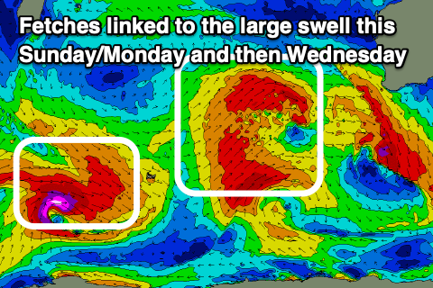
We’re due to see back to back strong frontal systems, but none of them will be overly significant. What this will result in is a prolonged run of large mid-period W/SW-SW swell, building Saturday and peaking through Sunday afternoon/Monday morning.
Size wise, the peak in energy looks to hit the 12ft range in the South West later Sunday and Monday morning, with 3-4ft surf across Mandurah.
Saturday will be smaller and with strong N/NE tending N/NW winds, shifting W/NW to SW through Sunday as one of the swell generating fronts clips us.
Monday then looks to see winds back right off and shift E/SE across Perth and Mandurah, though remain moderate to fresh from the S/SW across the South West, better Tuesday with E/NE tending N/NE winds.
Longer term, a large pulse of SW groundswell from a strong polar system at the back of all the incoming activity is likely Wednesday and with strong NE tending N winds. This will favour some spots over others but we’ll look at this in more detail Friday.
We might see a return to onshore winds and building surf later next week but check back Friday for the latest.

