Average week of waves
Western Australian Forecast by Craig Brokensha (issued Monday May 20th)
Best Days: South West magnets Thursday, Perth and Mandurah Saturday morning and selected spots Sunday morning
Features of the Forecast (tl;dr)
- Fading swell over the coming days with variable winds
- Small-moderate sized, inconsistent W/SW swell Thu with E/NE tending N/NE winds
- Late increase in moderate sized, mid-period W/SW swell Fri, peaking Sat AM
- Stronger SW groundswell for the PM Sat
- Moderate W winds Sat, light E/SE-SE to the north in the AM
- Stronger swells building Sun and more so next week with NW to SW winds (N/NE tending NW Sun)
Recap
Not much in the way of surf on the weekend with fading swell into Saturday, best across the South West magnets that handle the north-east winds.
Today we’ve got small to tiny surf and strengthening N/NE winds.
This week and weekend (May 21 - 26)
The coming days will be lay days with easing surf and variable winds, bottoming out across the region.
On Thursday a small pulse of inconsistent W/SW swell is due, with it generated in our far swell window, south and south-east of Madagascar late last week and into the weekend.
No major size is due with a kick to 4ft due in the South West Thursday, tiny to the north and with an E/NE tending N/NE breeze.
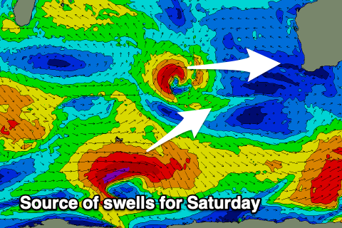
From Friday and more so the weekend we’re looking at a more active outlook, with a flurry of back to back frontal activity due to develop in the Indian Ocean, projecting up towards us.
Later Friday’s/Saturday’s swell will be generated an initial mid-latitude low forming north of the Heard Island region mid-week, with a moderate + sized mid-period swell due to the 4-6ft range in the South West, 1-2ft across Perth and Mandurah.
A stronger polar low forming just behind the mid-latitude system is due to generate some stronger SW groundswell into the afternoon, reaching a stronger 6ft to occasionally 8ft in the South West and 2ft to the north.

Conditions Saturday look average and onshore across the South West with a moderate onshore, cleaner and more variable to the north.
Behind these initial systems, stronger activity is due to be drawn up towards us, generating larger levels of W/SW groundswell from Sunday into early next week.
Winds unfortunately look to have a westerly bias with Perth and Mandurah performing best. More on this Wednesday though when surf windows become clearer.

