Slim pickings following a great run of swell and winds
Western Australian Forecast by Craig Brokensha (issued Friday May 17th)
Best Days: Today in the South West, selected spots for the keen in the South West Sunday
Features of the Forecast (tl;dr)
- Easing swell tomorrow with strengthening E/NE tending NE winds, easing later
- Small-mod sized W/SW swell Sun with strong NE tending N/NE winds
- Easing swell Mon with strengthening NE tending N/NE winds
- Small, inconsistent W/SW groundswell building Wed, peaking Thu AM with N/NE winds
- Building swells later next week and into next weekend
Recap
The surf continued to pump across the SOuth West yesterday with a reinforcing pulse of mid-period SW swell maintaining surf in the 5-6ft range across the magnets, down to 3-5ft today with strong offshore winds.
To the north, Perth and Mandurah maintained 2ft sets, smaller today and back to 1-1.5ft
A reinforcing SW swell should keep wave heights around 4-5ft this afternoon across the South West as winds ease.
This weekend and next week (Apr 18 - 24)
I hope you’ve made (or will make) the most of the swell and good conditions this week as the coming period is wishy washy with weaker, trickier swells and less favourable winds.
It’s due to the lack of any major frontal activity through the Indian Ocean and Southern Ocean, with flukey mid-latitude lows and cut-offs to deal with.

Firstly, the swell will ease through tomorrow with strengthening E/NE tending NE winds, easing later.
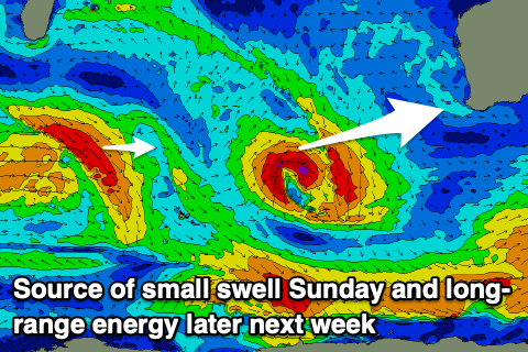
Sunday will then see even stronger NE tending N/NE winds along with some new mid-period W/SW swell.
The source is a tight mid-latitude low that formed yesterday to our west and isn’t expected to bring much size above 4-5ft+ in the South West, 1-1.5ft to the north, with local N’ly windswell likely being more dominant in metro locations.
The swell will fade Monday as strengthening NE tending N/NE winds persist, going variable into Tuesday as a weakening trough moves through.
Following this, there’s nothing that stands out until later in the week, with a strengthening mid-latitude frontal progression due to fire up between us and the Heard Island region.
Building levels of W/SW-SW swell are due from late week but more so next weekend, further into early the following week.
Winds initially won’t be great owing to the progression clipping the state, but we may see more favourable winds from next Sunday onwards. More on this Monday. Have a great weekend!


Comments
Couple of New Margs Cams eh.
Shoulda seen them last week, great vision!