Make the most of the coming days before things go quiet
Western Australian Forecast by Craig Brokensha (issued Wednesday May 15th)
Best Days: Today, tomorrow, Friday
Features of the Forecast (tl;dr)
- Easing SW groundswell tomorrow, slowed by a moderate + sized mid-period SW swell tomorrow AM, and a smaller spike during the day Fri
- E/SE winds tomorrow with weak sea breezes, fresh E/NE tending variable Fri
- Stronger E/NE tending NE then N/NE winds Sat
- Moderate sized W/SW swell Sun with strengthening NE tending N/NE winds
- Easing swell early next week with N/NE winds
Recap
Monday’s swell eased back into yesterday morning with clean conditions that were best suited to the swell magnets across all regions.
A new, inconsistent SW groundswell arrived into the late afternoon and has peaked today with great 6ft surf across the South West with 2ft sets to the north/
We’ve also got some new cameras for the Margaret River region, namely Mainbreak and Southside, with upgraded Yallingup vision of The Bubble and Mainbreak.
Mainbreak on the cook today
This week and next (Apr 16 - 24)
Today’s SW groundswell is due to ease slowly into the end of the week with the South West performing the best out of all the regions.
Perth and Mandurah are due to be fading from 1-1.5ft, while a reinforcing pulse of mid-period SW swell should maintain 4-6ft sets across the South West tomorrow morning, easing through the day and then down from 4ft Friday.
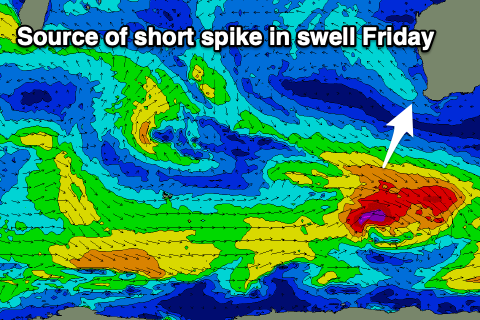
There’s the chance for a little spike back to 4-5ft through Friday as another glancing SW swell pushes in, generated by a strengthening frontal system tracking south-east past our swell window today.
This will be short-lived and ease back through Saturday from 3ft+ or so.

Winds will be great over the coming days, and E/SE tomorrow morning ahead of relatively weak sea breezes, fresh E/NE tending variable on Friday. Stronger E/NE tending NE and then N/NE winds will favour the south magnets come Saturday as the swell fades.
Moving into Sunday, winds are due to deteriorate and shift stronger NE-N/NE as an approaching mid-latitude low slips south-east past the state.
This will be along with a new mix of W/SW swells, generated by the earlier stages of the low. Fetches of strong to near gale-force W/SW winds should produce a spike in size to 4-5ft+ in the South West, 1-2ft to the north but with those poor winds.
Unfavourable N/NE winds will continue into early next week as the well fades, with nothing really of note at all until the following weekend. This is when we may start to see some strong frontal activity pushing up and into us, but check back Friday for more on this.


