Good run of surf this week
Western Australian Surf Forecast by Craig Brokensha (issued Monday May 13th)
Best Days: Today, tomorrow, Wednesday morning, Thursday morning in the South West, selected breaks Friday morning in the South West
Features of the Forecast (tl;dr)
- Good W'ly swell today, easing tomorrow with moderate E/NE winds, shifting S/SW mid-PM
- Inconsistent SW groundswell building later tomorrow, peaking Wed
- Fresh SE-E/SE winds ahead of sea breezes Wed
- Reinforcing, mid-period SW swell Thu AM with similar winds to Wed
- Easing swell Fri with fresh E/NE winds, tending lighter N/NE
- Smaller Sat with strong E/NE tending N winds
- Weak W/SW swell Sun with strengthening N/NE-N winds
- Easing swell Mon with SE tending SW winds
Recap
We saw building surf through Saturday across all regions with the local low generating some good waves across the metro locations with favourable winds, less so across the South West.
Yesterday was much better across all locations with cleaner conditions and some better reinforcing SW groundswell mixed in with easing levels of W/SW swell. Margs was in the 5-6ft range with 3ft sets across Mandurah and 2ft+ waves in Perth.
This morning there was a temporary low point in energy across the South West but our new W'ly swell has since kicked to 6ft with clean conditions, 2-3ft in Mandurah and 2ft across Perth.

New swell kicking during the AM
This week and weekend (May 14 - 19)
The fresh pulse of W'ly swell for today was generated by the second of the two mid-latitude lows firing up in our close-range swell window and we'll see this easing in size temporarily ahead of the next pulse of less consistent, SW groundswell into late tomorrow afternoon and Wednesday morning.
The source of the groundswell was a polar low that formed west of the Heard Island region last week, projecting a fetch of initial gale-force winds before weakening.
It'll be inconsistent but 6ft sets are due across the South West Wednesday with 1-2ft sets in Mandurah and 1-1.5ft across Perth.
Winds look great with a moderate E/NE offshore tomorrow morning, shifting gusty S/SW with a trough and change through the mid-late afternoon. Wednesday will then see winds shift back to the SE to likely E/SE across the South West (fresh), with lighter E/SE winds across Perth and Mandurah.

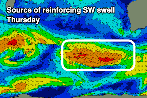
The easing trend into Thursday looks slowed thanks to a strengthening frontal system south-west of us today, generating some small reinforcing SW swell energy for Wednesday evening.
Easing 5-6ft sets should be seen in the South West, tiny to the north along with a moderate to fresh SE-E/SE morning offshore.
Another reinforcing pulse of swell is due Friday but the strengthening frontal system linked to this looks to form late in our swell window and it doesn't really look to be over 4ft for the main part in the South West, tiny to the north again.
Winds will shift E/NE and strengthen into the end of the week and weekend as a small high pressure cell moves east, under us and a small mid-latitude drifts in from the Indian Ocean.
No major swell is due off this low Sunday, with EC having the system much weaker than GFS and conditions will be average in any case with a strengthening N/NE tending N'th breeze, likely reverting back to the SE on Monday.
Unfortunately swell wise, there's nothing too significant on the cards, so make the most of the current and coming days of swell.

