Funky west swells with improving conditions
Western Australian Forecast by Craig Brokensha (issued Friday May 10th)
Best Days: Perth and Mandurah tomorrow morning, Saturday, Sunday, Monday, Tuesday morning, Wednesday
Features of the Forecast (tl;dr)
- Mod-large sized W/SW swell Sat, easing with variable winds (SE to the north)
- Better SW groundswell Sun with E-E/SE tending E/NE winds
- Mod-large W groundswell Mon AM, easing with E-E/NE winds
- Inconsistent SW groundswell building Tue, peaking Wed with E/SE morning winds
Recap
The swell bottomed out into yesterday and today we’ve got building winds and swell out of the north.
This weekend and next week (Apr 11 - 17)
The current increase in local winds are thanks to an incoming trough which is deepening into a low directly off our south-west.
A brief fetch of strong to gale-force W/SW-SW winds should kick up a spike in mid-period SW swell for tomorrow morning that looks to come in at 6ft to occasionally 8ft in the South West, 3ft across Mandurah and 2-3ft in Perth.

This is a little upgrade on Wednesday’s downgrade, and looking at the local winds, we’re expected to see variable breezes (SE Perth and Mandurah) and lots of lump across all locations. Though metro locations are worth a paddle.
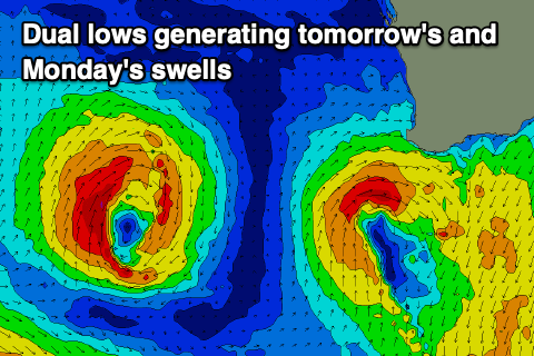
This swell will ease into Sunday as a stronger, reinforcing SW groundswell arrives, generated by a healthy but small polar low this week.
5-6ft sets are due most of tomorrow in the South West, with locations to the north easing from 1-2ft.
Conditions should be much better with an E-E/SE offshore across all locations, tending E/NE into the afternoon across the South West and more sea breezy to the north.
Our secondary pulse of W/SW swell for Monday morning, off the secondary low looks on track, but size wise it’s a little tricky. This low will be tight and track a little further north, favouring the metro locations, but also be quite intense.
Size wise it should fill in Monday and provide 6ft to occasionally 8ft sets in the South West with 3ft sets across Perth and Mandurah along with morning E-E/NE winds, holding into the afternoon. This is above model forecasts.
We’ll see this swell ease Tuesday but a mix of mid-period swells are due to build through the day, peaking Wednesday.
The source is a healthy polar frontal progression, but strength wise there’s nothing too significant expected. We’re looking at patchy fetches of strong to at times gale-force W/NW winds and this looks to limit the size to the 6ft range in the South West, 1-2ft across Mandurah and 1-1.5ft Perth.
Winds look favourable each morning and offshore, but we’ll review this Monday.
Longer term the outlook remains a bit wishy washy but there are stronger storms on the cards for mid-late month. Check back Monday for the latest. Have a great weekend!

