Deteriorating conditions with mid-latitude systems inbound
Western Australian Forecast by Craig Brokensha (issued Wednesday May 8th)
Best Days: Today in the South West, Perh and Mandurah Saturday morning, Sunday in the South West, Monday across Perth and Mandurah, Tuesday and Wednesday in the South West
Features of the Forecast (tl;dr)
- Easing W/SW swell tomorrow
- Strong E/NE-NE winds tomorrow, tending N/NE into the PM
- Strong N/NW winds Fri, tending W/NW later
- Weak, moderate sized W/SW swell Sat, easing with variable winds
- Better SW groundswell Sun with E-E/NE tending variable winds
- Mod-large W/SW groundswell Mon AM, easing with strengthening S/SE winds
- Inconsistent SW groundswell building Tue, easing Wed with E/SE morning winds
Recap
The surf bottomed out into yesterday morning with clean conditions but not much to show new swell wise until today.
Today looks better with clean conditions and some new, inconsistent W/SW swell that’s coming in at an inconsistent 4-5ft across the South West magnets with tiny 1-1.5ft sets to the north.

New swell lines today
This week and next (Apr 9 - 17)
Today’s swell is due to ease into tomorrow and winds will strengthen from the E/NE-NE during the morning, shifting N/NE into the afternoon thanks to an approaching frontal system-come mid-latitude low.
As the system nears closer Friday and deepens into a low, strong N/NW winds will be seen, shifting W/NW into the afternoon. These winds will kick up some poor, local windswell from the NW, but with no quality.
Winds are due to abate quickly into Saturday, tending variable across the South West thanks to the low quickly clearing south-east Friday evening. This will be ahead of the next, stronger mid-latitude low moving in from the west, but coming back to the swell, and the weak and fast nature of the low looks to limit the South West to a weak 5-6ft in the morning, easing through the day with 2ft+ sets across Perth and Mandurah.

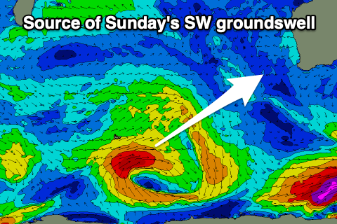
Into Sunday morning, some better SW groundswell from the base of the storm generating the mid-period SW swell is due, with a small fetch of strong to gale-force W/SW winds due to produce 5-6ft sets in the South West, 1-2ft to the north. Conditions look clean for this swell with an E-E/NE offshore, variable into the afternoon.
The secondary mid-latitude low is due to fire up quickly behind the first initial system, but come in temporary stronger. A fetch of gale-forece W/SW winds should produce a larger W/SW groundswell for Monday morning to 6ft+ in the South West, 2-3ft to the north.
The models aren’t resolving this swell very well and local winds are tricky but look to strengthen from the S/SE through the day, swinging more E/SE on Tuesday as the swell eases.
Another inconsistent SW groundswell is due from a strong polar frontal progression on the backside of the mid-latitude low, with fetches of gale-force W/NW to W/SW winds due to generate a good lift in size for Tuesday afternoon and Wednesday morning.
At this stage it looks to be in the 6ft range across the South West but we’ll confirm this on Friday.

