Good surf developing from late week
Western Australian Forecast by Craig Brokensha (issued Wednesday May 1st)
Best Days: Saturday morning, Sunday morning, Monday morning in the South West, Tuesday morning in the South West, Wednesday morning in the South West
Features of the Forecast (tl;dr)
- Strengthening N tending NW winds tomorrow
- Mix of large, close-range SW swell building Fri (peaking late) with some inconsistent W/SW groundswell also slowly building, peaking Sat PM
- Fresh SW winds Fri (S/SE to the north in the AM)
- Moderate to fresh S/SE tending strong S/SW winds Sat (SE to the north in the AM)
- Reinforcing, large SW groundswell Sun AM, easing with S/SE-SE tending S/SW winds
- Easing swell Mon and Tue with morning S/SE-SE winds Mon, E/SE Tue
- Moderate sized, inconsistent mid-period W/SW swell building Tue PM, easing Wed
Recap
Small, windy, easing surf back from 3ft across the South West magnets yesterday, tiny today. To the north there’s been no swell at all with a good dose of rain through yesterday afternoon.
This week and next (Apr 2 - 10)
We’ve got a lay day tomorrow as the swell remains at a low point along with strengthening N tending NW winds as a tight, strong mid-latitude low forms south-west of us and pushes slowly east.
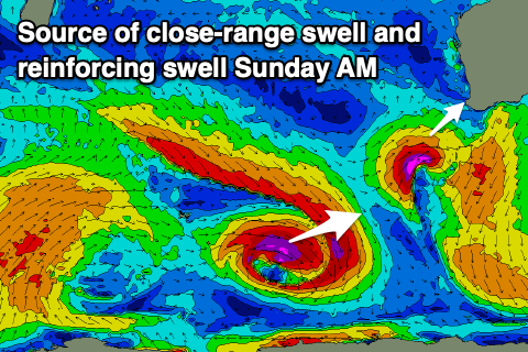
This low is still set to generate a large, short-lived spike of SW swell for Friday, peaking into the afternoon/evening.
With a fetch of gales right on our doorstep, we should see a good spike to 8ft+ across the South West, 3ft on dark across Mandurah and 2ft to possibly 3ft in Perth.

Winds will swing SW and create average conditions across the South West on Friday as the swell builds, with early S/SE winds to the north, shifting gusty S/SW-SW into the afternoon.
Saturday morning looks a better bet with the localised swell due to ease as some better, long-period W/SW groundswell fills in, peaking later in the day.
The source of this groundswell is a strong frontal progression that fired up to the south of South Africa on the weekend and projected slowly east up through the Indian Ocean. The progression has since weakened, with the groundswell now on the way towards us.
The long-period forerunners are due on Friday, but the bulk of the swell is due Saturday with strong 10ft surf in the South West into the afternoon, 2-3ft across Mandurah and 2ft+ in Perth. The morning is likely to be a similar size in the metro regions.
Winds should tend S/SE into Saturday morning across the South West, better and SE to the north with strong sea breeze into the afternoon.
Sunday looks similar as the swell eases, though periods of SE winds are due across the South West. The easing trend will be slowed by the arrival of a reinforcing SW groundswell generated by a disjointed, but strong low forming around the Heard Island region today. Fetches of severe-gale W/NW-W/SW winds should maintain 6-8ft sets in the South West with 2-3ft surf across Mandurah and 2ft waves in Perth.
More favourable morning winds will develop into next week across the South West and the swell looks to continue easing, dropping into Monday and Tuesday morning ahead of a moderate sized pulse of mid-period W/SW swell later in the day.
As touched on Monday, the source will be a broad but not overly strong low firing up south-east of South Africa over the coming days. No major size is due with the South West only likely to come in at a slow 4-5ft+ or so. Longer term the outlook is slow so make the most of the coming swells.

