Windy but improving easing surf from tomorrow
Western Australian Surf Forecast by Craig Brokensha (issued Monday March 18th)
Best Days: Tomorrow, small waves spots in the South West Wednesday morning, Friday and Saturday in the South West
Features of the Forecast (tl;dr)
- Large SW-S/SW swell this afternoon, easing tomorrow with strong E/SE winds developing through the morning, easing then tending S/SE later in the South West
- Small, fading swell Wed with gusty E/SE-E tending E/NE winds ahead of late sea breezes
- Strong E/SE winds Thu but small
- Late increase in inconsistent SW groundswell Thu, peaking Fri with strong E/SE winds, easing
- Easing swell Sat with strong E/SE winds, easing
- Smaller for the following days ahead of large to extra-large surf later next week
Recap
The weekend was average thanks to the swell bottoming out on Saturday with clean conditions, choppy and poor yesterday as a front clipped the state.
This morning we've got windy conditions and poor surf again, though building in size. A larger SW groundswell is due to reach 6ft to possibly 8ft later today but options will be limited.
This week and weekend (Mar 19 - 24)
This afternoon's pulse of SW-S/SW groundswell has been downgraded a touch thanks to the low and fetches generating it coming in a little weaker than forecast on Friday.

It's due to peak into later this afternoon and start easing tomorrow from the 5-6ft range across the South West, with 1-2ft sets to the north.
Winds will be strong but shift E/SE across all locations as tomorrow morning progresses, easing into the early afternoon before reverting back to the S/SE in the South West.
The swell will fade into Wednesday, back from a smaller 2-3ft in the South West with gusty E/SE-E winds, tending E/NE ahead of late sea breezes.
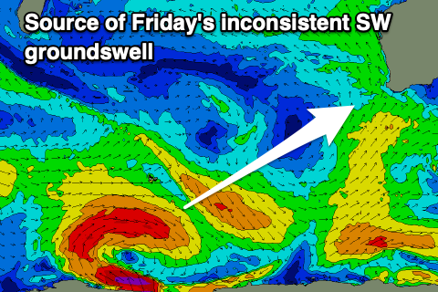
As touched on in Friday's forecast, the next noticeable swell will be an inconsistent SW groundswell that's due to arrive later Thursday but peak Friday across the state. The source was a strong polar low that formed west of the Heard Island region on the weekend, with the low now weaker and still producing a healthy fetch of strong to gale-force W/SW winds on the polar shelf.

It'll be inconsistent but sets to 6ft are due on the South West magnets with Perth and Mandurah only due to see 1.5ft waves. Winds on both Thursday and Friday mornings look offshore, strong from the E/SE on the latter with sea breezes likely to be suppressed, with similar winds due Saturday as the swell fades.
The surf looks to remain slow through the weekend and early next week ahead of a large to extra-large, prolonged SW groundswell event into the end of next week. The source will be a significant cold outbreak to our south-west owing to a strong node of the Long Wave Trough, though we'll have a closer look at this on Wednesday.

