Good run of swells and conditions this period
Western Australian Forecast by Craig Brokensha (issued Monday March 4th)
Best Days: Wednesday, Thursday, Sunday morning in the South West for the keen, Tuesday morning next week
Features of the Forecast (tl;dr)
- Mod-large sized mid-period SW swell for Wed, peaking through the day with gusty SE tending E/SE winds, ahead of late sea breezes
- Easing swell Thu with moderate E-E/NE tending variable winds
- NE tending NW then SW winds Fri with small surf
- Weak, moderate sized SW swell Sat with strong S/SE winds, easing Sun with E/SE morning winds
- Large S/SW groundswell for Tue with fresh E/SE-SE winds ahead of sea breezes
Recap
Friday morning’s large SW groundswell eased off into Saturday morning with strong offshore winds and good 5-6ft sets, best as winds eased through the afternoon. Perth and Mandurah dropped back quite a bit in size with 1-1.5ft waves left on the former, 1-2ft across the latter.
Yesterday was funky with a trough bringing tricky and varying winds, tiny across the metro locations with easing surf from the 4ft range in the South West.
Today the trough has moved through, bringing onshore winds and smaller surf. A lay day.

Windy surf Saturday morning
This week and weekend (Mar 5 - 10)
The coming forecast period looks much better with back to back swells with generally favourable and workable winds.
Tomorrow will start small but into the afternoon some new mid-period SW swell should start to show in the South West ahead of better pulse Wednesday, peaking through the day.

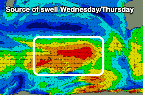
The source of this mix of swells has been back to back, healthy frontal system firing up around the Heard Island region, with the best currently generating a good fetch of strong to gale-force W’ly winds on top an active sea state.
This should generate a moderate-large pulse of mid-period swell for Wednesday, coming in at 6ft across the South West (odd bigger one magnets) with 2ft sets in Mandurah and 1-2ft across Perth.
Conditions look good for Wednesday with gusty SE tending E/SE breezes through the morning ahead of relatively weak and later sea breezes, E/NE-E on Thursday, tending variable with easing surf.
Good 4-6ft surf is still due into Thursday morning in the South West, 1-2ft to the north.

Friday looks smaller and more so a lay day with early NE winds due to shift NW ahead of a SW changes as a strengthening mid-latitude trough pushes up and into us. This will bring some low quality SW swell for Saturday to 5-6ft in the South West but with no power and strong S/SE winds. Sunday will become cleaner with an E/SE offshore but with easing 4ft sets across the South West, tiny to the north.
Of greater significance is a stronger polar low firing up just east of the Heard Island region Friday, with a good fetch of severe-gale W/SW-SW winds due to project slowly through our southern swell window.
A large S/SW groundswell is due from this source later Monday, though peaking Tuesday, with good 6-8ft sets due in the South West, 2ft across Mandurah with smaller 1-2ft sets to the north. Winds look to swing offshore from the E/SE-SE in the morning but we’ll have a closer look at this and the size on Wednesday.

