Good swells into the end of the week and weekend with improving winds
Western Australian Surf Forecast by Craig Brokensha (issued Wednesday February 26th)
Best Days: This morning, tomorrow morning, protected spots Friday, Saturday, Sunday
Features of the Forecast (tl;dr)
- New, moderate sized + mid-period SW swell tomorrow AM, ahead of a larger groundswell later in the day, peaking Fri AM
- Mod-fresh SE winds tomorrow (S/SE-SE to the north) ahead of strong sea breezes, strong S/SE-SE Fri AM
- Easing swell Sat with strong SE tending E/SE winds, easing
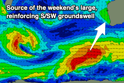
- Large, reinforcing S/SW groundswell later Sat, easing Sun with gusty E winds, tending variable
- Easing swell Mon with S winds
- Smaller Tue with strong S/SE winds
- Large, SW groundswell building Wed with gusty SE tending S/SE winds, peaking Thu with E/SE-SE morning winds
Recap
The swell lifted slightly into yesterday morning across all locations but it was mainly weak energy with less than perfect winds and conditions, ahead of some stronger mid-period SW swell into the afternoon.
This swell has held well into this morning with great conditions in the South West and surf to 4-6ft, tiny but surfable to the north and to 1-1.5ft in Mandurah, 1-2ft on the sets across Perth.

Good surf this AM
This week and weekend (Feb 27 – Mar 3)
Today's swell will ease into tomorrow, though replaced by a fresh pulse of new mid-period SW swell in the morning and then stronger groundswell later, peaking Friday morning.
The source of these swells was a strong polar low, with a pre-frontal fetch generating tomorrow morning's spike to 5-6ft in the South West, 1-2ft across Mandurah and 1-1.5ft in Perth, while stronger, post-frontal fetches generated the larger groundswell. This should come in around 8ft, holding Friday morning before easing with 2-3ft sets in Mandurah and 2ft waves across Perth.
Local winds look SE tomorrow morning across the South West, S/SE-SE to the north ahead of strong sea breezes, while strong S/SE-SE winds with the peak of swell Friday morning will favour protected spots across all locations.
Easing surf is due Saturday with tricky, strong SE tending E/SE winds, easing into the afternoon before freshening again later. Some good reinforcing groundswell energy is due later Saturday, generated by a healthy trailing frontal system that's currently firing up to our south-west, on the back of the low.

This should boost wave heights back to 6-8ft later in the day across the South West Saturday, easing from 5-6ft Sunday morning and 1-2ft to the north.
Gusty but easing E winds are due on Sunday, likely variable into the afternoon creating great conditions, while a trough looks to bring S'ly winds Monday as the size eases further.
Longer term, another healthy swell producer looks to fire up around the Heard Island region on the weekend and early next week, producing another large SW groundswell for mid-late next week with SE winds. We'll have a closer look at this Friday though.

