Tricky weekend with more activity into later next week
Western Australian Surf Forecast by Craig Brokensha (issued Friday February 23rd)
Best Days: Sunday morning selected spots, but more so Monday morning in the South West, Thursday morning, Friday morning protected spots
Features of the Forecast (tl;dr)
- Strong S-S/SE winds tomorrow with smaller surf, S/SW-SW to the north with a localised windswell
- Easing windswell Sun with a small mid-period SW swell for the South West
- Strong SE tending S/SE winds Sun
- Mod-fresh E/SE winds Mon AM with a touch less size
- Moderate sized, mid-period SW swell for later Mon, peaking Tue/Wed
- Strong S/SW winds Tue, weake S/SE Wed AM
- E/SE tending S/SW winds Thu with a large, building SW groundswell
- Large SW groundswell Fri AM, easing with strong S/SE winds
Recap
Our mix of W/NW cyclone swell and mid-period W/SW swell came in strong yesterday, and it's always tricky to forecast such sources as they're quite rare. We saw a solid and bigger than expected kick across the South West to 6ft+, 3ft in Mandurah and 2-3ft across Perth with improving conditions as the morning went on. Protected spots were best in the South West.
The swells have eased back into this morning with great conditions and surf to 4-5ft in the South West, 2ft in Perth and Mandurah.

Chunky sets early afternoon yesterday
This weekend and next week (Feb 24 – Mar 1)
Tomorrow looks smaller and a lay day with a return to strong S-S/SE winds in the South West as a trough slides in, SW-S/SW to the north.
Winds should shift back SE on Sunday but still be strong with some easing windswell across metro locations from 1-2ft, while the South West should see a bump in mid-period energy to 4ft.
Monday should be cleaner as winds ease and tend E/SE through the morning with a slight drop back to 3-4ft in the South West, tiny to the north. Later in the day bit more so Tuesday our better pulse of mid-period SW swell is due, generated by a good fetch of strong W/NW winds moving in on top of a weak front that was south-west of us yesterday.
This should provide a bit more energy to 4-5ft+ in the South West, 1-1.5ft to the north, holding Wednesday with another pulse of reinforcing energy.

Conditions unfortunately look poor as the front clips us Tuesday, bringing strong S/SW winds that should ease and tend S/SE through the morning Wednesday. Thursday looks best with E/SE-SE offshore winds and a larger, building SW groundswell that's due to peak into Friday morning.
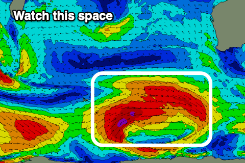
This swell, as touched on earlier in the week will be generated by a stronger polar low firing up on the tail of the current activity. Pre-frontal severe-gale W/NW winds look to shift SW behind the low, generate a large SW groundswell in the 8ft+ range across the South West, 2-3ft Mandurah and 2ft Perth. Friday's winds look a bit average and strong from the S/SE but we'll review this Monday. Have a great weekend!

